For all of the less than “pleasant weather” we had during this cruise, the Gulf of Alaska made up for it. If it had not been for a low running swell from the Siberian coast, the sea would have been as flat as a mirror. Yesterday morning the weather forecast indicated strong winds with 30 kts. coming from the East, but by 9 pm. last night the forecast had been suddenly changed to light winds. It looked as if: “that to great success the bad weather is staying for another 3 days at another location”. A sort of circus that is not moving because things are going so well in a certain area. We are now supposed to get those strong easterly winds this coming Sunday night. We just had a little pitching to remind the guests that we are still sailing on a ship and they are not living in a land based hotel. Last night the clouds lifted high enough to show the Fairweather mountain range and we could just see Mt. Fairweather’s top 20.000+ feet above the water. On a clear day it is a spectacular sight when the evening sun sets on it. If we get some wind tomorrow and on Monday, maybe it will blow the clouds away and we will get such a sight. We are almost in the middle of June but we have not seen much sunny weather yet. ……………………….. Alaska is known to have the highest suicide rate of the US States per 1000 people and if the summer goes on like this 2012 will be a record year.
So we happily trundled on, staying about 20 miles south of the coast line. Not by choice but because we sail in a straight line and the Alaskan coast is curved. Mother Nature is not very good at straight lines and thus the only one that you see in Alaska is the border line with Canada. At least most of it. In the South East panhandle where people live, it is also a wobbly affair. I wonder, when they defined Alaska, how they decided to draw that straight line in that location. 5 miles more to the West or to the East and you might have missed the biggest oil or gold find of the century.
We are sailing all day long through the Gulf of Alaska which is in principle defined by Kayak Island to the East and the Alaskan Mainland to the West. Contrary to the rest of the Pacific, it is fairly shallow, courtesy of the outflow of sediment from the glacial cap that covers most of Alaska. Thus when we sail westwards we first have to sail under Kayak Island with Cape. St. Elias, and then we have to make sure that we clear the reefs to the North of Middleton Island. The sea is not much deeper than 2 to 300 feet. This is one of the reasons why the waves can be so nasty here. There is not enough depth in the sea to absorb the energy and that results in the forming modified ground waves, which when whipped by the wind, can only continue to grow and grow as they cannot get rid of their energy by stretching in long waves. Very nasty in spring and autumn and absolutely horrible in deep winter.
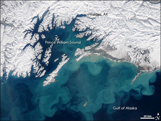
Courtesy: NOAA: Moderate Resolution Imaging Spectroradiometer (MODIS) on NASA’s Aqua satellite on March 13, 2008.
That sediment is continuously coming out of all the openings between the islands and rock patches along the coast. Because of the strong currents the sediment does not settle down in Prince William Sound but is flushed out to open water. There it tries to settle down but then the waves, whipped up by the wind churns it all up from the bottom again. The reason that you never find “crystal clear waters” in the Gulf of Alaska. The Sea here always has a leaden dark color to it, due to the sediment in it.
Luckily today there was not much churning; there was just a low swell running in from far way with a height of about 8 feet. Nothing to worry about as most of it was taken care of by the stabilizers with just a little pitching as the swell and the angle was such that the stabilizers could not completely handle it.
Tomorrow we will be in Seward and it will be an early morning. For the guests to get on time to their destinations or to Anchorage airport, the first groups have to leave at 06.30 That means that we have to start unloading luggage by 05.30 That means that we have to be docked by 05.15 at the latest. And that means that I have to get out of bed at 03.00 in the morning to be on time at the pilot station.
Looking at the weather, I do not even know what to predict at the moment. It should be blowing North 7 knots with a chance of showers. So we will see.


June 11, 2012 at 12:00 am
Your description of the view of the Fairweather Range was so vivid to me. You transported me back three years ago (on the Veendam, the same itinerary), when we had the same view. My wife and I spent the sunset (later evening, of course) in the Crows Nest viewing the sun splashed across this spectacular mountain range. I realize now that it is a rare site that way, and we were lucky to see it. Remains my favorite evening at sea to date!
I enjoy your blog. Thanks for letting us travel along with you while we dream about our next Holland America adventure!