Because the ms Amsterdam does the Sitka to Seattle run it has the option to go either inside Vancouver Island or to sail around it and re-enter the Inside Passage via Strait Juan de Fuca. Going inside Vancouver Island is the route that we all know very well. Sailing through Johnstone Strait and Seymour Narrows and ending up in Vancouver. It is sheltered and provides great scenery. The only disadvantage is that it takes much longer. The ship has to slow down for Seymour Narrows, for picking up pilots and there are several speed restrictions on the way such when passing Campbell River and the stretch to Victoria south of Vancouver. Because the ship sails straight from Seattle to Alaska which are all American ports, it has to call at one foreign port during the voyage. This in order to comply with the Passenger Service Act of 1886; although most people are more familiar with a similar act which is also applicable, the Jones Act.
The latter comes into play when you try to transport and land passengers while travelling between two American ports. Ships sailing from Vancouver do not have this issue as they start and end their cruise in Canada and thus according to American law start and end the cruise in a foreign port. Hence that you go through American Customs and immigration in the Vancouver terminal to make it all a bit easier. With the Seattle run that does not work and to comply with the rules it means that you have to call at Victoria, which we will do tomorrow evening. Victoria is located at the South East point of Vancouver Island and that makes taking the outside route around Vancouver Island a real good alternative. It only brings the dilemma that as a cruise guest you have to make a decision between visiting Victoria or seeing more of the Inside Passage. This also changes the whole schedule for having pilots on board.
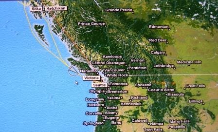
Running the outside route of Vancouver Island. Before entering the Strait of Juan de Fuca
For this Seattle run it means that the American Pilot can be disembarked right outside Sitka, where pilotage water stops. Then the ship remains outside pilotage waters all the way to the Victoria – Sea buoy. Strait Juan de Fuca is wide enough to be considered open waters and that means for Canada that the inland water way pilotage starts at Victoria and for the USA at Port Angeles. To make sure that we as sailors do not do anything naughty, there is Radar and VHF coverage in the Strait to monitor all traffic moving in and out.
The border between Canada and the USA runs right through the middle of the Strait and thus this monitoring has also been nicely divided. Ships approaching or leaving Strait Juan de Fuca, report to Tofino traffic. This is a Radar/Radio Traffic monitoring station located on the northern – Canadian – shores of Strait Juan de Fuca and they keep an eye on who is coming in and going out. Once inside the Strait there is the moment that you switch you’re reporting over to Seattle Traffic. They keep an eye on all the traffic going all the way to the Seattle/Tacoma area or until you change course to the north and head for Canada. If you turn south, then you pick up a pilot at Port Angeles to visit any of the ports in the Puget Sound area. If you turn north towards Canada then you are transferred to Victoria Traffic and proceed to the pilot station there to obtain a pilot for any Canadian port, all the way up to Prince Rupert if needed.
When I first came on the coast here in 1979, I read an article in the National Geographic about how they checked & followed the traffic in Seattle. This was before good Radar coverage, AIS and real time satellite etc. The article showed photos of USCG men actually moving little models over a large size chart of the area. Intrigued about this, I managed to visit them during my cadet year and it was most interesting to see how it went and with the models how well they were able to predict if things were “hotting up” or not. Now that is all gone and the Control Station can see the whole area on radar screens and digital charts and follow the ships moving in real-time over the screens. That makes it even safer. The main challenge is now how to communicate developing situations to the crew on the bridge of the ships. Some crews, especially from China and Korea, speak highly original forms of English, and the well-meant advice from “Traffic” is not always understood or implemented the way it is intended.
So tomorrow evening we are in Victoria, which is, I think, the most British of all the City’s in Canada. The weather should be good, but as the sun shone in Ketchikan, it normally means that you have to pay for it. Thus the Captain might be looking for quite some time tomorrow at a very small world due to very low hanging clouds.

July 13, 2014 at 1:44 am
Fascinating!
It’s nice how technology has made the traffic monitoring more reliable. Although….I do wonder if those little wooden boat models are hidden away in a box for ‘just in case’. We’ll probably never know