Most of the time there are more ways to get to a destination, especially if there are islands in the way. So also for the Great Bahama Banks. They form a formidable barrier for everybody who has to go from Florida to the Caribbean. Only a hover craft might be able to go directly, hovering over the water the banks and the reefs but anything which floats and sits in the water has to find a way through it or around it. For the cruise ships there are only two choices, either via the north sailing between Freeport and Nassau or completely around it via the Old Bahama Channel in the south.
It all really depends on a few logical reasons of which route the ship will take. Distance and Weather. The shorter the distance, the less fuel we need and there we go. Except if the weather is bad, then the Captain has to make a decision taking into consideration how bad the weather will be and how much it will affect the Guests; how much faster we have to cover the extra distance or how much later he is willing to arrive. To put it bluntly: is the final destination worthwhile dealing with a rocking ship for a while or not?
This is what the captain thought of yesterday before leaving port as well. In this case the decision was not as difficult as the weather out there was not that bad. The weather front brought rain but not much swell and the ship would move (give me a ship which does not move at all) but not considerably so. Thus this left only the last question, distance.
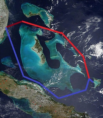
The north – red route – is a little bit shorter than the south – blue route.
And then it depends on where you go. For East Caribbean Cruising, the Bahamas are the top end of a triangle with the long point reaching San Juan. Thus from Ft. Lauderdale if you sail to the Northern islands of the East Caribbean going north of the Bahamas is the shorter distance. We are going to Puerto Rico and St Thomas and we follow the shorter route. We just make a small deviation in order to call at Grand Turk Island.
We are not the only one. The Navigator of the Seas is heading for Labadee, RCI’s private resort on the North West side of Haiti and she is off our port bow, slowly gaining as she has a slightly longer distance to travel. She will catch up with us again in San Juan, arriving roughly at the same time.
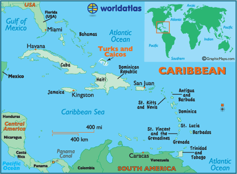
The Turks and Caicos Islands are at the end of the Grand Bahama Bank but somewhat on the side.
The Turks and Caicos Islands are part of the Bahama chain of islands but together with Great Inagua Island they are on the edge and does not really form an integral part of the Grand Bank system. When looking at the map there is a larger stretch of water which separates them from the other islands compared to the real Bahama Islands. Maybe because of this it is that they are not part of the Bahamas but are a British Overseas Territory or a Dependency with a Governor appointed by the British Crown. But although it is nice to be British, you also have to live, so the USA dollar is the local currency.
For years we tried to call here but there was only a small dock and we had to operate a tender service. That was fraught with issues and the swell often made it impossible and the ship sailed away in vain, with a lot of unhappy campers on board. The island did not have the money to invest in a larger tender dock with a suitable breakwater and thus the cruise business passed by. This status quo lasted until about 6 years ago when Carnival decided to put in a Pier and a small Resort. The island is at a perfect distance for a cruise ship call as it is exactly one day sailing away from Florida regardless of whether you take the North route or the South route.
Now there is a nice long Pier which can handle two large cruise ships and a resort has been constructed near the beginning of the cruise pier creating a nice stop for the guests who otherwise would never have visited Grand Turk Island.
Weather for tomorrow: Partly Cloudy with a chance of rain. Temperatures 84oF / 29oC. If the frontal system gets a move on tonight we might still have a nice day tomorrow.

Leave a Reply