In accordance with the rules of the road we followed the Vessel Traffic Separation scheme. We crossed the North Sea over the English side and picked up the Southbound Traffic lane towards the North Atlantic Ocean. We were going full speed as it is a tight schedule to Lorient in France and that meant that we were overtaking ship after ship. Around 6 am we passed Dover and were hoping for a glimpse of the White Cliffs but it was not to be as at that time a white cloud descended over the Prinsendam and its surrounding area. The good weather was finally catching up with us and producing fog. Luckily it was not that early and thus we did not wake up the guests in the suites too early. Having a suite is the best thing you can have on a ship but you have to take in consideration the fact, that what the captain gets, the suite owner gets as well.
There is more movement as you are higher up and when the captain starts blowing the horn, right above your head, the suite occupant will have to enjoy it as well. I knew it was going to be a nice day again, so it was just a matter of time before the rising sun would be strong enough to burn off the fog and return to good visibility. In the end it took until 11.00hrs and then the world was wide open again.
During the last two cruises, we had calm weather and thus no ships movement at all while doing our travels. Even along the Norwegian coast the ship was very steady. But today we felt the motion of the ocean again. It has been quite nasty in the North Atlantic, South of Iceland, and the swell generated there did reach the British Isles and the French coast. Together with a fresh Breeze, that sustained the momentum, the ship moved about a little bit. Not that much but it was a new sensation after so much time of nothing at all.
However by the early evening when we turned eastwards, sailing under the coast of Brittany, the swell started to travel with us and that made the ship quiet again. Tomorrow we will be Lorient, in South Brittany, France for a half day call. The entry and departure of the ship from the port is dictated by the strong current, generated by the Ebb & Flood. The flow is being pushed through a very narrow passage creating a very strong current, halfway between the time of high and low water. That means that we have to arrive at a certain time and leave at a certain time, otherwise the ship cannot be controlled while in the passage and hence we might end up going aground in the passage. That would upset a lot of people, including myself and thus we do our utmost to prevent that and arrive at the time stipulated by those with the local knowledge. Luckily for our arrival it works out that we can arrive at our scheduled time which coincides with the beginning of the ebb. For departure we will have to leave an hour early, because the prediction of the harbour master is that under the current circumstances, the flood tide will be too strong if departing at the scheduled time of 1400 hrs.
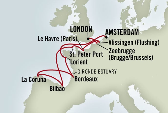
 A while ago, a reader asked me if I could post a schedule of the cruise that the Prinsendam was making and I am blogging about, so it was a bit easier to follow and to put the stories in a better context. So I have pulled this chartlet from the HAL website and that should make it easier.

July 11, 2010 at 7:59 pm
Thank you for the map. The on-line itinerary map usually disappears for a cruise that has started and is in progress, and I am sure many of us do not have a ‘library’ of brochures to use as a reference. Now I see how big the distance is between Amsterdam and Lorient… The distance seems very small between Zeebrugge and Vlissingen– perhaps a chance to rest–but then again, the map does not show how many locks there are to navigate…
I do hope Holland wins today.
July 11, 2010 at 8:49 pm
This is very interesting, I am really looking forward to the next port of Bordeaux it is a lovely city. It would be very interesting to sail down this river in a beautiful Liner
I am on pins at the moment with this football I so want Holland to win.
July 12, 2010 at 6:49 am
THANK YOU Captain Albert! I’m the one who asked for the maps of your current cruises.
I too, as “C in Ballard” said, would go to the HAL site to check the current itinerary but as they said, it disappears when the cruise starts, so you can’t see it. You posting it helps very much “seeing” where you’re going and blogging about.
Thank you again!!
SB in Nebraska
July 12, 2010 at 1:19 pm
Captain Albert, I have come to follow you not only by this blog, but in near real time at: http://www.marinetraffic.com/ais/ Most of the time your position is updated within a few minutes. I was fascinated by your trip through the Kiel Canal and your trip into and out of Amsterdam.
I have navigated a very large ship (aircraft carrier) through the English Channel and in most areas around Great Britain and the Mediterranian. I now enjoy watching the ship traffic on the web site (versus from my bridge).