With the wind in the back we sailed away from Aruba and that following wind, nearly Gale force wind will remain with us until we come in the lee of Panama. For most of the day we will sail above an area (about 10,000 feet above) that is called the Colombian Basin. Basically the name indicates a fairly flat area (if you compare hilly ridges of a few 100 feet with the average depth of 10,000 feet) surrounded by high mountain ranges. The South and Eastern side are Panama and Colombia which come as land above sea water level but are basically nothing else than but tips of these mountain ranges. Because some of these tips are so wide and large we call them continents. As we are approaching Panama on a straight course, with somewhere behind us major ports and also the only route for ships to follow to get to the East side of South America, it is busy with shipping. Ships either coming or going to the Panama Canal itself, or to the port of Manzanillo just to the East of Cristobal. Manzanillo is a recently created container port which came into life when Panama started to redevelop the Panama – Trans Continental – Railroad. Now there is for container services the option to land containers at one side of the Canal, send them across by train and load them back on ships at the Balboa side. It saves the Panama Canal transit. Tomorrow we will see several times during the day one of the trains with containers coming by.
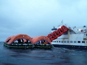
 Today I am using my blog to answer some questions that were posted in the recent days. The first one is about large rafts being lowered; and the cruise ships having to swing around and to re-dock to do the other side as well. This is a fairly recent development in the cruise industry. It comes from the airline industry where for a long time chutes with life rafts are in use in case of an emergency. The airplane door is opened and a chute deployed and at the end several large life rafts are inflated to collect the passengers that come sliding down. Especially the ferry company’s thought that this might work very well for them and they were the first to install them. They are used in addition to the required lifesaving equipment (lifeboats and life rafts) as these chutes are not yet part of the Solas.
Some versions have covered liferafts and some have open. Also the chute comes in various options from looking like a bag to the inflatable construction you see here in the photo.
Since then also some cruise companies have installed them but I have not heard anywhere if they are preferred above the conventional systems or not. One of the great challenges with these systems is that they have to be inspected once a year and thus offloaded. That is what was seen in port with the cruise ship re-docking. Secondly, once packed they stay in their containers ready for use, so it is also difficult to train the crew with them. You will need a small “training chute” on board to take the crew through the motions. Also if there would be burning oil on the waves, it might be difficult. Advantages are, disembarkation is fast, as everybody just slides down and they can be used with a larger heeling angle than a lifeboat, so you have more time to get everybody off.
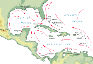
 2nd question. Are the Caribbean currents made stronger by the predominant wind? Yes they are. An Ocean current is caused by the following influences: Gravitational pull by sun and moon, salinity differences in the water, differences in temperatures, Coriolis effect (due to turning of the world)and even the form of the land can cause currents when it pushes slow moving water together in a funnel. Wind is a very important fact, at least for surface current. If there is a predominant wind, such as the trade winds, then the constant “push” over the water surface will cause water movement. Eventually that push becomes part of the water circulation of the world’s oceans. On average the trade winds are less in the winter than they are in the summer and as a result the current around Aruba and in mid Caribbean is less strong in the winter. For reasons that elude me a little bit, the past few months, January, February and March have been very blustery with the result that we see some very pronounced currents that affect the ship. For more information see: http://en.wikipedia.org/wiki/Ocean_current. In the area that we are sailing at the moment, the Colombian Basin the current is a mixed bag. The main flow, north of Aruba tends to veer to the North and loses its strength in this area. The Colombian Counter current coming up along the coast near Cartagena pushes against that. Then the return current that bounces off the Panamanian mainland does the same. As a result we see the ship sometimes going faster and sometimes go slower while the engine speed is constant.
As already posted we will enter the Panama Canal entrance at 05.00, be in the first locks at 06.15 and after that we might be on schedule, we might not be. The weather should be overcast in the beginning and maybe break later.

April 4, 2012 at 8:13 pm
Captain Albert I just watched you and Statendam pass through Miraflores lock between 11:45-12:07 PDT I saved eleven screen captures.
Greg Hayden
April 4, 2012 at 8:18 pm
Hi Captain Albert & crew! I see you!!!:) Watching your movement through the Miraflores locks was quite interesting. This was the 1st time I’ve watched the Panama Canal webcam and actually felt like I knew someone on the ships…pretty cool! Thanks for the link today.
April 4, 2012 at 9:50 pm
interesting
on Normal ferries like pride of Hull – there chute stored in speical doors area some are located at lifeboats on ferries
on some cruise ships – they have chutes stored in boxes which on lifeboat deck – i think statedam has those but its on newer ships – i think you might seen them