It was not a very nice morning when we approached the island. Overcast, windy and rainy. The rain and the wind eased off later but the clouds stayed. The dock is located on the SW side of the body of the Grand Turk Island which puts it in the lee side of the island. Thus the island protects it from the ocean swell and it should help with reducing the wind as well and create a lee. Unfortunately the island is as flat as can be, so there is not much lee side to enjoy. For centuries the main source of income was harvesting salt from the sea by means of salt plains and you can only have salt plains if the surface is flat and preferably can be put under water when needed. Luckily the wind was dead east and with the Pier only under a slight angle from the East it did not cause much of a problem for docking the Westerdam.
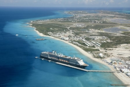
The Noordam was the first ship docking at the new pier in 2006. Note how small the dredged area is around the dock and how near the deep water is near the stern.
Although the ship has ample power to deal with adverse winds (read wind on the beam) there is not much room to drift when coming in as they did not dredge very widely around the dock. Barely two ships widths of room to come in and that gives only 32 meters extra to play wide and that is not that much. So the captains concern is always where the ship is in perspective to this dock; how close are we to the closing line of the markers on the sb. side. And thus the officer parked on the wing at the not- docking side keeps a close eye on whether he still sees the beacons open, closing or closed (which means……… if you see them in line, you are on the edge)
They built the dock out as far as they could, as far as the shallow water reached. The end of the dock is almost at the edge of where the rim of the island falls away into the abyss which is 3000 feet down. The last part of the dock is only a catwalk to each of the mooring bollards. This is not a problem for the linesmen and the ropes but it can be a problem for putting out the gangway. On the Vista Class ships the gangway is preferably at the amidships staircase as there is the largest handling area for the Scanners and for people to wait. The forward staircase is also possible but it is all a little bit tighter there for traffic control.
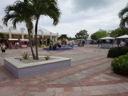
The central square of the Resort village. It is open for general public as well.
Going more forward to put the amidships gangway on the main part of the dock means the ship has to go as much forward as possible. For the draft this is possible but when they constructed the pier they did not put as many bollards on the pier as we as captains would have liked. Thus with the nose further in, the ropes are more vertical than what we prefer them to be. The longer the ropes, the lesser the angle with the vertical and the more weight they can carry before they will snap. Not that they are likely to snap as they can carry /hold an awful lot of weight, but more length/less angle is better. Thus the docking location for the ropes is also something which the captain has to take into consideration for the docking plan. If you are expecting very windy weather during the day, then putting out the lines in the best possible way becomes extremely important.
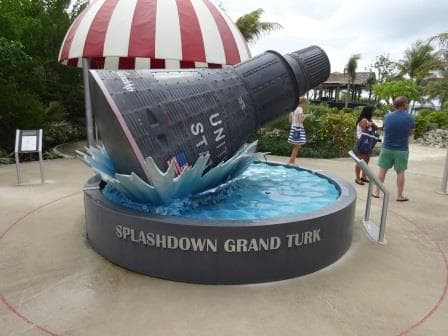
Centre piece of the exhibition, a not completely life size model of the landing capsule. On an island where nothing happens this splash must have made a big impact, to generate such a set-up.
Today we had only 20 knots of wind blowing under a slight angle and thus the line configuration was not of critical importance hence we used the center gangway and staircase. I walked ashore briefly to see what they had built here through the years and the dock /resort village is similar to other places in the Caribe. Big Duty Free, a nice beach, a nice pool, plenty of Water sports and several Diamond stores. What they did have as well was a little exhibition about the Mercury Space program in the 1960’s. Close to Grand Turk was the area where John Glenn splashed down when he returned after being the first American in Space. And they made a nice little open air exhibition out of it.
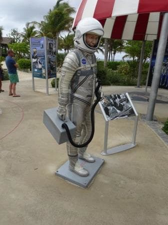
John Glenn is also world famous on Grand Turk Island.
We sailed at 3 pm. and will now spend the night and tomorrow morning at sea, before arriving at San Juan at 1 pm. for an afternoon and late evening stay. There are supposed to be at least two other cruise ships in port, the Norwegian Jem and the Navigator of the Seas. Weather will get better, at least for the day, with partly cloudy skies, temperatures of 86oF / 30oC and a regular Trade Wind breeze.
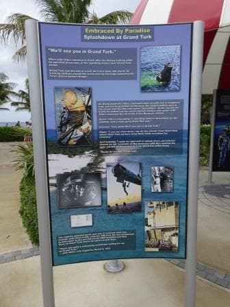
They have a whole series of posters with the information about the Mercury Space Program and it is very nicely done.

November 16, 2015 at 4:30 pm
Alan Shepard was the first of the Mercury astronauts in space. John Glenn was the first to orbit.
November 17, 2015 at 11:54 am
Alan Shepard was the first American in space (second human, after the Russian Cosmonaut Gregarin). John Glenn was the first American astronaut to make a complete orbit of the earth.