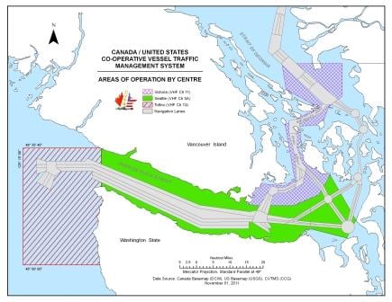
As far as distance is concerned it is only a short hop between Victoria and Seattle. As far as the captain is concerned it is a very long hop to make. That has to do with changing pilots and the broken sleep on this stretch. The ms Statendam pulled out just before 23.00 last night and then disembarked the pilot outside the harbor entrance. Although in Canadian waters the area is so wide and is covered by VTS that it considered safe enough for all the ships to do their own thing. At least when going in the direction of Strait Juan de Fuca.
Thus for the next hour we sailed by ourselves to the south, crossing the Strait of Juan de Fuca and ending up at Port Angeles pilot station where we embarked the Pudget Sound Pilot who guided the ship to Seattle. We have now arrived in American Territory. So the captain had departure, the crossing and then the pick up of the new pilot. A soon as the ship is safely under way, there are about 4 hours of downtime before he has to be back on the bridge for arrival, as we dock most of the time around 05.30. By the time docking is finished it is nearly 07.00 hrs. and that is hardly a time to go back to bed as the whole world is waking up and demands attention.
If it there is some time, an early afternoon snooze might be available, but the ship sails already at 16.00 hrs. and at 15.30 there is the mandatory Guest boat drill which also requires the Captains presence and input. Then after moving off the dock and sailing back to the Port Angeles pilot station it requires the captain’s presence again. And if it were only the hours it would be just a day of regular routine but they are very intense hours as the bridge team is fully focused to ensure that everything goes according to plan.
Today the routine was upset a little bit as we had a change of command. Capt. Sybe de Boer went home and his position was taken by Capt. Vincent Smit. He will be in command of the Statendam for the next two months when Captain Chris Norman arrives who will take the ship first to Singapore and then to Sydney for the transfer to P&O Australia.
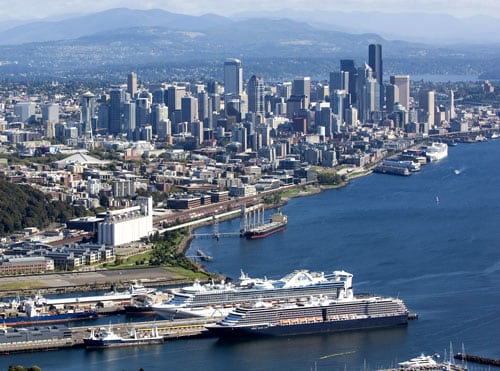
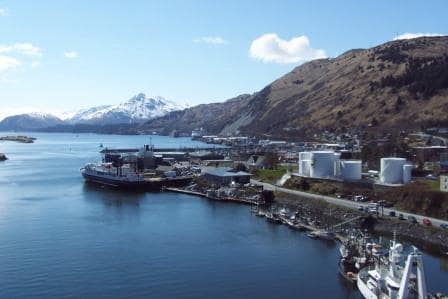
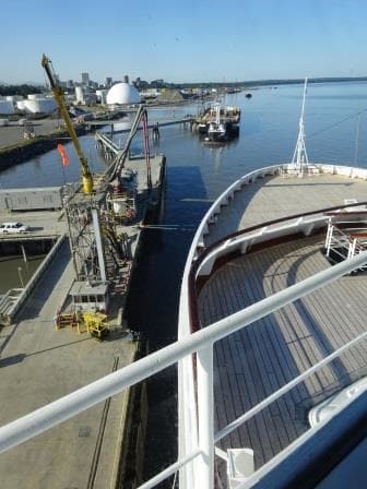
Smith Cove Cruise Terminal at Pier 91.
In Seattle we dock not in down town but at Smith Cove at Pier 91. Today we were at the West side of the dock, going Starboard side alongside. The other cruise terminal is at Pier 66 Bell street which is more down town. I spent some time trying to figure out what the better place to be is, as Smith Cove is quite a distance from down town Seattle. For the crew Bell Street would be ideal, almost in the middle of down town with Pike’s Market within walking distance. For the guests it is another story. There is much more space at Smith Cove for buses, taxis and for the loading of supplies. So operationally Holland America has the better spot. For glamour (being in every bodies* picture) maybe not so much.
What we also have in Seattle is Silent Disembark. Apart from a “welcome to the Port, we are starting now” there are no announcements. Guests are requested to stick to the times on their disembarkation paper. It makes sense to do that, as otherwise you will be stopped at the gangway anyway as your luggage will not have been offloaded yet into the terminal. So why should you leave if you can wait in the comfort of your stateroom? Holland America is the only large cruise ship company that gives this service. It puts a bit of pressure on the cabin stewards as it reduces their time do a complete clean of all the cabins before embarkation but it is a great service for the guests. To assist the cabin stewards help is called in from the dining room and with a concerted effort, all the cabins are ready by 11.30 hrs.
Seattle has a very well organized terminal with a lot of dedicated and friendly staff on standby who ensure that this silent disembark and effective luggage collecting really works. I saw this morning’s smooth routine with my own eyes as I was kicked off the ship as well for a short period; to help to reach “zero count”.
CBP wants to see a 000 on the security computer before they allow the flow to go the other way. I have to get off the ship as I live in limbo-land. I am crew according to the company but as I am not part of the ships complement, I am considered a guest by the CBP. (They call this a non-revenue passenger) So I have to get off, show my face to the CBP Officer, wait until the 000 has been reached and then I can return. I use the waiting time to call my Lord and Master at home as they have a really strong Cell Phone signal outside the terminal.
Tonight and tomorrow we are retracing our route back north again. Staying West of Vancouver Island so we can make Ketchikan on time for the day after tomorrow.
Weather forecast for the North West Pacific: Not bad at all for the area. A light to moderate breeze with a low (6 feet) swelling running from the North West, so we can expect a gentle movement of the ship. Later on the winds are to increase but they will be following winds.
(*) nowadays maybe it should say not “in the picture” but more “in the selfie”.