- Captain Albert's Website and Blog -

Ocean Liner History and Stories from the Sea, Past and Present. With an In Depth focus on Holland America Line

Category: CaptAlExport (page 68 of 203)

25 Nov. 2014; At Sea.

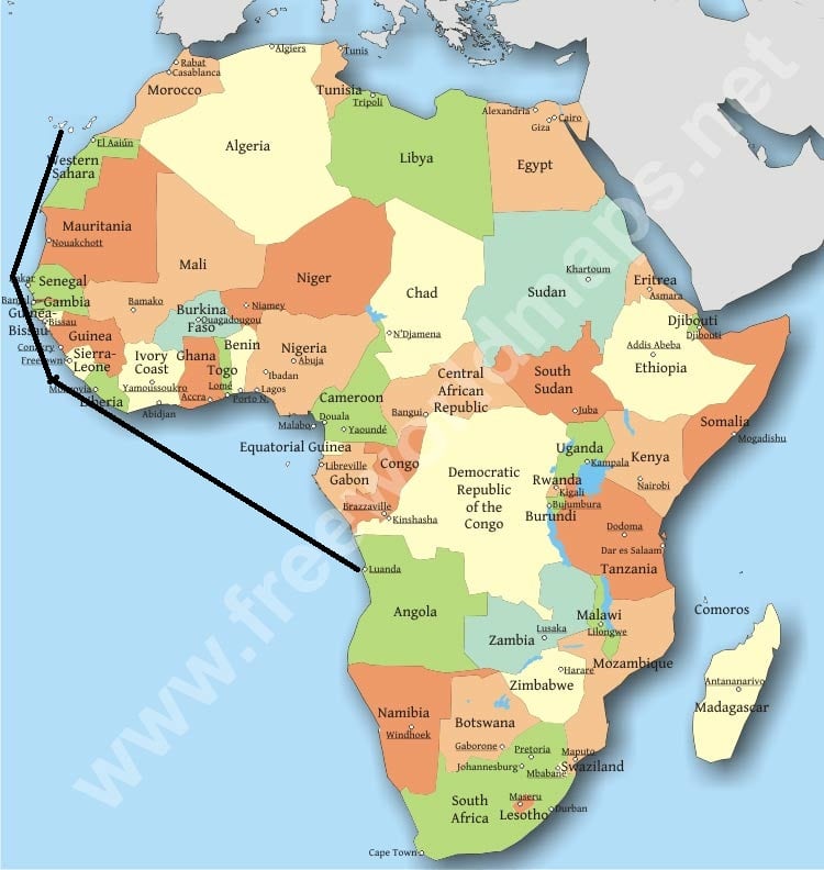
Today is our first day of that long haul all the way along the West side of Africa. The area that we are now in, close to the equator, is known to sailors as the Doldrums. 

download
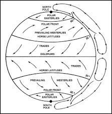
The area of very little wind.  It is caught between two area’s of trade winds and as a result there is basically “no wind left” to blow here. And indeed outside there is hardly more than about 3 knots of wind blowing. We call that a light Air.  It is almost always the same here and in the old days sailing ships could float here in becalmed weather for weeks, causing food and water to run out and scurvy to set in. Not nice at all. That was also one of the reasons for steamship companies to be very quickly established to Africa as well.  The North Atlantic was the first as the steamships reduced the crossing time (here mostly due to too much wind = bad weather) from six weeks down to 14 days, but this was quickly followed by routes to West Africa. Especially the British were very active here. There was a Dutch company as well but it was never very prominent. The Belgians had a much larger presence in this area as they owned the Belgian Congo.  A good second were the Portuguese who had the colonies Angola and Mozambique. The name Doldrum is 19th. Century and means dullard which in those days was a sluggish fellow.

Another piece of interest that surfaced today and had the guests focusing on was the volcano eruption in Cape Verdes. Everybody was at once concerned about having to cancel yet another port but there was no reason for alarm. The Cape Verdes are full of volcanos and this one has its own island. Basically the island of Fugo is the Volcano. There are houses scattered all over the mountain slope and there is a little town but it is all up and against the cone of the Volcano. Thus there is no point of refuge on the island and hence the call has gone out to evacuate everybody to one of the other islands. We will see the island on our portside when leaving the port of Praia. There is about 33 miles between the islands and if the Volcano is really active we should be able to see something as long as it is safe to sail by. It is not a good idea to be in the area when it starts raining pumice so we have to careful.

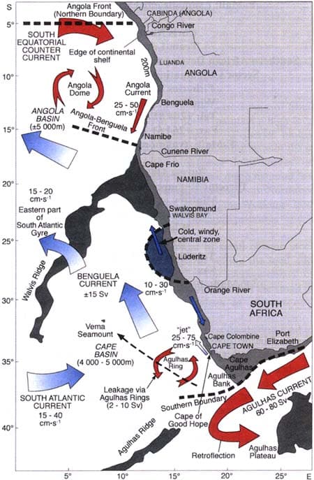
The land area under the sea is called the Angola Basin and the sea reaches depths up to about 5000 meters. Then it stays that deep (give or take a 1000 feet) until the ocean floor climbing again near the Mid Atlantic ridge. Above it the water swirls around quite nicely. The ship is now coming under the influence of the South Equatorial Counter Current which is part of that mid Atlantic rotating current system which I mentioned the other day. It flows from West to East along the Equator and when nearing the African coast takes on the name of Angola current. It then follows the coast a little bit to the south before it turns west again. While going west it gets a little push from the Benguella current, which brings cold water up from the Cape area.

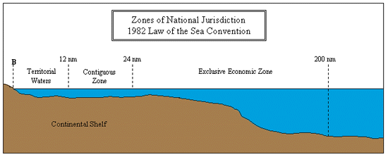
The SEC Current is thus pushing the ship to the East but luckily not full onto the bow and hence the ship does not lose too much speed. The deck officers only have to steer for drift to counteract this push in order to stay on the course line.  Although one would think that we are in the middle of nowhere here, this is not the case, as all the ships that are heading to or coming from Cape of Good Hope near Cape Town are on nearly the same courses as the Rotterdam.  Today we saw traffic that was related to the oil offshore industry and liner service to the ports on the South West coast of Africa but by late tomorrow afternoon we should see Tanker traffic going to and from the Persian Gulf. For these large tankers it is economically worth while to sail all the way around Africa and not to go through the Suez Canal. Although some of them are (still) too large to transit the Canal that might change in the near future as Egypt is going to build a new Canal parallel to the old one with the hope of attracting more traffic and also larger ships.

Tomorrow will be our second day at sea and we will be coming closer and closer to the Equator.

24 Nov. 2014; Luanda, Angola.

By 7 am we were docked in Luanda. This place has always been an important port for the region and even Holland America ships were calling there in the 1960’s. While HAL was not really an “African” specialist, then it was mainly the export of local products, now it is used mainly for off shore, due to oil exploration, which is becoming very important. As a result the whole bay area in front of the docks was full of Supply Boats when we got in.

The Luanda sky line. Fast developing if counting the number of cranes.

The Luanda sky line. Fast developing if counting the number of cranes.

The port does not have a dedicated Cruise Terminal; as a matter of fact they are not really focused on cruise ships at all. We are docked at the Cement Terminal and this morning when we arrived Port Security did not even know that we were coming. Somebody forgot to advice somebody, I suppose.  Also immigration was about 90 minutes late but at least then they cleared the ship in 30 minutes. If you expect to find on these sorts of cruises everything well organized on the shore side, then you had better stay home. On these real explorer cruises you have to go with the flow. Whatever that flow is. The fact that we are on some sort of expedition is shown by the requirement of having a valid yellow fever vaccination with you. Thus in the last few days the medical department has been busy ensuring that all the booklets were handed in and checked for validity.  No valid yellow fever vaccination, No go ashore.

All the white dotson the radar screen  are AIS indicators from boats involved in the off-shore industry

All the white dotson the radar screen are AIS indicators from boats involved in the off-shore industry

Most people took tours today as that was the safest way to see the area. We were advised that the boulevard was safe but warned not to go too deep into the side streets. Since the end of the Civil War, Angola is slowly coming back to normal but there is a very sharp divide between rich and poor and thus there are a lot of people who would like to go from poor to rich in a quick and easy way.  I walked ashore briefly but as we were also warned that taking photos of official buildings etc. is not allowed without permission, I have not much proof to show for it.  If you do take photos and you get caught, a prison sentence awaits or a hefty fine. As I was absolutely not interested in visiting the local prison, so I kept my camera my pocket. The boulevard is about 4 kilometers long and everything of some importance is along this boulevard. Shops, Restaurants, Cafés and a lot of official looking buildings. The oil exploration is bringing lots of money in and everywhere there is construction going on; although I did not get the impression that it was going very fast.  But maybe Monday is not a construction day in Luanda.

It is a real pity that this cruise has been affected by the EBOLA situation which required a number of ports to be cancelled. Thus Luanda is basically the only real Central African port that we visit. There are not that many ports around that we could divert to without running into some sort of issue. When we leave tonight at 10.30 pm. It will be followed by 7 days at sea until we come the Cape Verdes Islands.

blog africa mapWe will first sail on a straight North Westerly line to the corner of West Africa and follow the coast line until we can sail straight to the Cape Verdes. These Islands are located off shore from Africa and are not really any part of the Continent at all as they are volcanic in origin, being located on one of the fault lines in the North Atlantic Ocean. The Canary Islands which we will visit afterwards are a result of the same situation. An open crack in the earth’s core, causing lava to come out, which eventually gets so high that a Volcano rises out of the water and turns into a habitable island.

Map credit to: Daniel Feher www.freeworldmaps.net

Mr. Feher makes a lot of maps and charts and for those interested, his work can be found here: http://www.freeworldmaps.net/africa/ …………………

Thus we will have seven days at sea and my colleague and I will have our hands full with our training classes. The program calls for 8 hour days of training and instruction and then we need at least 2 hours in the evening to prepare for the next day.  I am only now starting to realize how specialized the work on a cruise ship is. A lot of people think that cruise ship officers spend their days around the pool, chatting up young and nubile ladies, but our work is as highly specialized as working on a Gas Tanker or in a Nuclear Sub. (Although we have the advantage that we cannot blow up so easily………………) Because of that, new joining officers have an enormous amount of indoctrination work to get through and this course is hopefully a good way to reduce that initial burden.  It should make it a lot easier for the new officers to settle into their job when they get to their own ships.

So tomorrow we are at sea, sailing far away from the African Coast until we come closer again near Liberia in about 3 days from now.

23 Nov. 2014: At Sea.

Then suddenly it got warmer around the ship in early evening of last night.  One would expect that it would cool down after dark and it did, but not that much. This sudden change was caused by the fact that the ship left the colder Benguela current and entered the warmer Angola current. We are getting into sub-tropical waters again.

As all the world’s oceans are connected there is a constant movement of water going on. Caused by the rotation of the Earth, by the pull of the Moon and the Sun but also because of constant winds such as the Trade Winds. As a result there is a flow around the continents but also rotating currents that circle between the continents.

There is a very sharp boundary between the cold water from the South going north and the warm water from the north coming South

There is a very sharp boundary between the cold water from the South going north and the warm water from the north coming South

The Benguela current comes from the south, from the Antarctic area and pushes cold water north along the west coast of the southern part of Africa. The winds which blow predominantly from the south along the coast of Namibia (something we witnessed in the past days) help to push this current up towards Angola.  Here it meets a down coming current, the Angola current which is part of this rotating system in the South Atlantic Ocean.  The approximate area where the Benguela current moves away from the coast is near Cape Frio, the cold cape, which makes sense in a way.

So in a couple of hours, the sea water temperature went up with nearly 6 degrees Celsius. Six degrees do not sound that much but taking into consideration how large this body of water is, six degrees is an enormous amount of energy that the sun had to spend to get it that warm.  It also has a direct influence on the outside temperature as the cooling effect of the cold seawater on the air has fallen away. Basically the temperature last night did not drop anymore from lunchtime but remained the same at 77oF or 25oC.

Tomorrow the temperature will vary again during day and night time but then at a higher level as we will remain in warmer waters now. It will not be until we are a long way past the equator before the sea water will get cooler again.

Most of this happened outside the scope of the Trainee’s in our little school class, who tackled today the art of giving training. At least the 8 deck officers. The 5 engineering officers were engrossed in pipes and steam and propulsion systems but the deck group needed to learn how to perform. At least that is the word I prefer to give to it.  If you want to pass on knowledge then the better your performance is in front of a group, the better the chance is that they will absorb at least something of the training/instruction that is been given.

Public speaking is not something everybody knows how to do and not everybody likes to do it but ground rules can be learned and that will then make the experience for audience and trainer already a lot better.  Apart from that the presentation itself is important. Not only the contents but the structure of the presentation. A lot of trainings and presentations do not have the desired effect because there is no structure or –even more important- there is no ending. It suddenly stops as the speaker has run out of material. Then the audience will only remember the “black hole” at the end and not the message that had to be brought across.

So today we spent time on what to train; the topic was lifeboats and life rafts, but also to ensure that each training had a beginning, a middle part, and an ending. And if possible that ending should have a cliff hanger. One wise sentence that the group which has received the training will take with them and remember.

Tomorrow, in two groups of 4 they will have to give a 20 minute training presentation. I will be less interested in the contents than in the way that they will engage the audience to get the message across.  If that all works out, then it will be a half day for them, and they can go ashore and explore Luanda in the afternoon.

We are expecting to dock around 07.00 hrs. The clearance should take about 90 minutes so everybody should be able to go ashore by 08.30. Noon temperatures are expected to reach 84oC or 28oC.


22 Nov. 2014: At Sea.

Today we were sailing along the coast of Namibia towards Luanda in Angola. Around 7 pm this evening we passed the border between the two countries, although today there was very little to see of the coast. We are staying about 12 miles out and cloud formations over the land make it not so easy to see the low lying coast land. We are at least 12 miles out, to stay out of any form of territorial waters, and that might need a little bit of explanation.

The world Seas and Oceans have been parceled up and allocated to the surrounding countries to ensure that everybody knows what belongs to whom. The system is not completely fail safe and we read regularly in the newspapers about countries quarreling over miniscule islands that are hardly big enough to pitch a tent on. However if the island is miniscule, the territorial sea around it makes it interesting to get even very small bumps of land under control.

Who has the right to own what is governed by UNCLOS, the United Nations Convention on the Law of the Sea. Every country who has signed this treaty is bound by the boundaries it sets. Which means that you can only bicker about what land (Island) is yours in order to extend the area of sea under your control.

There are several boundaries, called Maritime Zones.

1. Where the land ends. This is the base line and that is normally the low water line of a state. Everything inland of that line are the inland waters of a country.

Example: for deep sea ships here inland water way rules apply.

2. Then the next line can be 1 kilometer away or 3 miles and defines where certain Local and National Laws are still applicable.

Example: Florida has a sales tax on drinks. It applies also to cruise ships when they are within the 3 mile zone of the Florida Coast.

3. The next line is the 12 mile zone line. This is called the territorial sea. Here a country can apply all its National laws.

Example: A country would have the full right to erect a windmill park, without needing permission from anybody else.

A ship has the right “of innocent passage” through this area, which means that the local state cannot stop the vessel unless it is violating safety or pollution rules.

4. The next line is the 24 mile zone line. This is called the contiguous zone. The adjacent country has the right to exercise supervision.  Also here the law guarantees freedom of travel.

Example: if two fishermen would be fighting over a catch in this zone, then the country attached to this zone could dispatch a fisheries inspection vessel to see what it was all about.

5. The final zone line is the EEZ. The Exclusive Economic Zone. Here the adjacent state has the exclusive right to “explore and exploit, conserve and manage natural resources”. If it allows an oil rig in this area, then it also has jurisdiction over that oil rig.

6. Beyond the EEZ is the “High Seas” which is in principle not governed by anybody.

Of course some countries are closer to each other than 12 miles, (think about the USA and Cuba) and then local agreements are made about where the dotted lines run.

eez2As a ship we can sail basically anywhere outside the 3 mile zone without having to deal with the Country along which coast we sail.  However every country has the right to apply all sorts of law up to the 12 mile zone. As it is impossible for us to know what every country is up to, we tend to stay away for this distance to avoid any hassle. Sometimes we can’t and then we have to go closer.

The quarreling that we read about in the newspapers is caused by point 4 and 5. If you can extend your zones a little bit by claiming a reef or something as being part of your country then you can extend you EEZ and you might get control over a large oilfield that you could then explore and exploit.

Tomorrow will be another sea day and then we will call at Luanda in Angola for one day. The outside temperatures keep climbing and are supposed to reach the 70oF tomorrow, up from the mix sixties of today. However it still felt chilly today courtesy of a fresh breeze blowing from the south and bringing cold air from the Antarctic.


21 Nov. 2014; Walvis Bay, Namibia, 2nd day.

21 Nov. 2014; Walvis Bay, Namibia, 2nd day.

Walvis Bay a town of low buildings with an endless desert at the horiozn

Walvis Bay a town of low buildings with an endless desert at the horiozn

So I had the sincere intention to go ashore today to sample the delights of Walvis Bay. In order to find out what was going on the trainee’s had been encouraged to go ashore yesterday afternoon. They reported that apart from a lot of sand there was not much to do, unless you took the tours. Yesterday evening a lot of the concessionaires went ashore and all ended up in the same Bar/Restaurant. It is more or less the only one there as well it seems and it is so prominent that it is even mentioned in the Wikipedia write up about Walvis Bay.  So in the end I gave up and concentrated on today’s task at hand.

Today the ship was staging the weekly 3 alarm cycle drills and that took all my focus. As reported before all Holland America line ships have now adopted the three alarm system and eventually all 110 ships controlled by Carnival Corporation will have the same procedures. Our routines are remaining the same it is only a new frame work that has been established with an extra alarm that gives everybody, crew and guest alike, more time to prepare for the abandon ship procedure. So we also continue our training in the regular way. Today we had a fire drill and the trainees were attached to the various teams to learn the procedures. When we do a drill, we always have an assessor who reviews the procedures and then highlights the good things and the things that can be improved upon.  I took that role upon me, as with hopping from ship to ship I can compare various routines and are able to get best working practices initiated. That took most of the morning and then it was time for the class room again to further review the drills and do some more theory. This time NLV procedures were on the list, including washing your hands often to avoid spreading germs.

While we live in our little world on the ship, there are some major changes taking place within our company. As might be known, a year ago Holland America, Hal/Princess Alaska Operations, Princess Cruises, P&O Australia and Seabourn were concentrated in the HAL group under the Carnival Umbrella. Stein Kruse became the leader of that group. The aim was to find common ground between the various brands so all the products could be strengthened while at the same time not losing anything of the uniqueness of each Brand.

This has now been taken one step further with having the operational departments (Nautical and Technical) working very close together as it will improve the operational output and it will not affect the uniqueness of the various companies. We already go altogether to the same simulator in Almere Amsterdam where we follow the same bridge and safety routines (= 3 alarm system) so there is nothing wrong in ordering the same spare parts as well.  All the departments that deal with the guest experience, including Hotel Operations, are kept together and now come under a new President.

His name is Orlando Ashford and he comes to us from Mercer, which is a company according to our company’s press release, that is the global consulting leader in talent, health, retirement and investments.  This means that Stein Kruse now steps out of the daily leadership of Holland America and will concentrate on overseeing the HAL Group.  It is not every day that we get a new President so I thought it would be worthwhile to mention this.

blog radarThe good ship Rotterdam left from Walvis Bay at 5 pm. Sailing as she had come in, through the narrow dredged channel. Now we will spend two days at sea and then we will come to Luanda for a full day call on Monday 24 November.

The weather forecast for tomorrow is a bit of a mixed bag. A bit of swell and partly cloudy skies, which means it can go either way. Temperatures are slowly rising again and are expected to top 18oC / 64oF tomorrow. It has been strange the last few days to see desert on the land side and to have chilly temperatures that you do not directly relate to the desert. But as the desert can be very cold as well, it is quite normal to have these chilly days in this part of the world. But somehow I relate the desert with always scorching temperatures and sitting in the shade.


20 Nov. 2014; Walvis Bay, Namibia.

When hearing the name, it almost sounds as if we are home again. Walvis is Dutch for Whale and thus we are in the bay of the whales. Not that they are there, it is more that in the old days it was a port of assembly and refuge for the whaling ships.  In the area there were large concentrations of Southern Right Whales. Nowadays it is an industrial port that is very much alive and created at the south end of the dock area. About 85,000 people live here and although the whales are gone, fishing is a very important part of the local economy. Although most of the coast was once colonized by the Germans around the turn of the 19th/20th century, Walvis Bay was first in the hands of the British and later on controlled by South Africa until in 1990 when South West Africa became independent then Namibia and Walvis Bay became part of that country in 1994. Now the town is expanding with more tourism, plans for a new container terminal and also rumors that the Chinese want to establish a naval base here.

The port is sheltered to the south and thus we had to sail in a curve around a peninsula, called Pelican Point which creates this Bay of the Whales. The port is located in the far side of a shallow bay and the ship had to sail through a dredged channel to get to a turning basin in front of the docks. That whole process takes about an hour and then it depends on how fast the linesmen are in securing the ship.  The pilot came on board at 08.30 and then the ship sailed into the bay, swung around at the dock and was docked Starboard side alongside before 10 am. Also the authorities were alert and by 10.10 we got the ding-dong from the cruise director announcing that the ship had been cleared and all could go ashore.  As the port is quite extensive in size it is about two kilometers to down town and the ship had organized a shuttle service for those who were not on tour or did not want to make their own arrangements.

Looking over the port into the town we saw a similar sight as yesterday, lots of yellow sand and white buildings. Except here we now have trees sticking out from between the houses and thus the town is not completely arid. We are slowly moving to the north so the climate should become more temperate but we did not notice it today. It was dry and very chilly something I had not expected from this area with so much desert around.

We are staying overnight here, as with so many ports along the coast being excluded for various reasons, we at least can offer the guests a few things here. Night life is not that exuberant but the shop people on board had already discovered a nice bar and restaurant. Sometimes I think that they have a sort of secret database where all the ships shoppies add their combined knowledge to, because wherever we go, they know of a good place to party.   They were not completely happy today as they first had to attend training given by yours truly. Apart from the trainee class I am also helping out the regular deck officers with training. Some of those trainings the officers have never given themselves, so they attend to learn, and if I take away some of the others then it will reduce their workload.

Our school class is progressing well, with 13 eager persons soaking up all the information being thrown at them. This afternoon they were off and were given the chance to go ashore to see Walvis Bay.  It might be a very long time before they will return to this port, as Holland America only calls here during world cruises and an occasional around Africa cruise. Tomorrow we will find out what they thought about the place.

19 Nov. 2014; Luderitz, Namibia.

Indeed the good ship Rotterdam arrived as planned on Luderitz roads at 0700. The Authorities came onboard and started clearing the ship. All Guests were required to present themselves in person but the system worked in such a way that once been, you could go ashore with the tender. Not all at the same time of course, you still needed to get a tender ticket but at least they did not keep everybody from going ashore until the final guest had been seen.

It was our plan to take the trainee’s on a tender tour once the rush to get ashore was over, so we spent the morning having them climb in and out of lifeboats and swinging out life raft cranes which are used to lower the life rafts of the crew. Everybody is taught the principles of lifesaving equipment at school but reality is slightly different. Mainly due to the fact that every time when a new ship is constructed, new equipment is bought and that equipment is most likely not the same as on the previous ship.  Even with sister ships such as the Rotterdam and the Amsterdam there can be vast differences. In the same way that are a large number of automobiles out there, so are there also a large number of different lifeboat types for sale.

By lunch time that was all done and then we were getting ready to take a tender for a spin but it was not to be. In the late morning the wind had been picking up and by early afternoon there was a considerable swell running around the ship. Not exactly weather to start playing in with a boat. All 4 tenders were now needed to maintain a regular tender service as the time needed alongside the platform increased as everybody had to be very careful when stepping in and out the Tender, due to the movement, and that costs time.  So we decided to postpone to another day. We will be docked in Walvis Bay for two days and if the authorities allow us, we can exercise a little bit then. Still disappointing as I did not make it ashore and now it might be a while before I make it back to this part of the world.

Which is a pity as Luderitz is a most peculiar place.  It has a sheltered bay which is accessible with ships of a draft of less than 8 meters, which meant for the Rotterdam that she was out of luck as she draws just over 8 meters.  Although discovered by Europeans in the 15th century it was not until 1883 that a town was founded which was eventually named after Adolf Luderitz who owned the land. In 1909 diamonds were found and the place turned into a boom town. As result is there is some nice architecture including Art Deco.  With the mining slowly shifting away in the 1920’s, the town lost its prominence step by step. Also the climate does not help to make the place attractive and while we were at anchor, we mainly saw brown, yellow and white (from the houses) colors but no greenery at all. Which with a rainfall of about 1 inch a year is not un-expected.  About 12,000 people still live there and that meant with the visit of the Rotterdam the population for the day went up with 10%.

Thus our guests had a windy day in Luderitz and a very bumpy tender ride back to the ship.  When all were back, we raised the anchor and sailed for Walvis Bay where we will arrive tomorrow morning at 10 am.

The weather is supposed to be somewhat similar but with less wind and less sunshine. Here we will dock and that means at least a more comfortable way to get ashore than what we had today.


18 Nov. 2014; At Sea

Today was a sea day and we have been sailing with the sedate speed of 14 knots along the coast of South Africa and Namibia. The coast with its brown mountains was just visible in the hazy distance.  We are having a very strong breeze of 26 knots blowing with us; which gives a relative wind of 12 knots and that makes it very pleasant on deck as the wind cools down the temperatures which reached the mid 70’s today. We are sailing with a slow speed as the distance between Capetown and Luderitz is one of those stretches, if you go full speed, you will arrive in the middle of the night. I have been given to understand that the night life in Luderitz is less than dynamic and thus the ship aims to be at the anchorage around 0700 maybe somewhat earlier.  We cannot dock here as the bay is too shallow and hence we have a long tender distance to reach inside the port.

As messing around with boats always has an inherent danger to go wrong, a tender port is even more meticulously planned than a docking port. Thus the Navigator in charge prepares a presentation for everybody involved and a Tender Briefing is held the day before. Thus today. As that is of interest to us as well we had the whole group of trainees attend.  We learned that Luderitz is located inside a bay and that it is thus well sheltered from anything that is not blowing directly from the North. Such an event is not forecast and that means nice sunny weather tomorrow with only a gentle breeze blowing. (Approx. 8 knots)

The tenders have to sail from the far left of the photo, around the NorthPpoint, all the way down to the small jety in the bottom of the photo . (Photo courtesy Stock Photo from the Internet)

The tenders have to sail from the far left of the photo, around the North Point, all the way down to the small jety in the bottom of the photo . (Photo courtesy Stock Photo from the Internet)

Less welcome was the realization that it is a long tender ride from the ships anchorage, around the corner into the bay, to the floating tender dock. There is a shoal that moves around and the far North end of this shoal is marked with a buoy. Still the local authorities do not seem to be convinced that the buoy stays with the shoal or vice versa and tomorrow each Tender will have a local pilot on board to ensure that the tender gets to go where it has to go.


This route is carefully discussed with the tender drivers to ensure that all understand on what side of the buoy they will have to stay. Having the benefit of a local pilot’s wisdom can only help the situation. A cruise ship that comes into port creates a sort of local invasion but when the ship is docked that is normally not noticed that much. When at anchor it becomes more evident and therefore apart from the Nautical people also Housekeeping was in attendance. When the first tender goes ashore, there are normally no guests onboard the tender as the ship has not been cleared yet. Even if they were allowed, there would be no room as all the gear that has to go ashore takes up most of the space inside the tender.

Hotel has a whole protocol to adhere to when being in a tender port and the Exe. Housekeeper is always very eager to have that protocol followed. A whole army of Housekeeping attendants then descends onto the tender, and later ashore, carrying umbrella’s, tables, towels, folding chairs, security stands, gel dispensers (against NLV)  and if the wind is not too strong, also a tent for providing shade. Then about 2 hours after the tender service starts, BLD (Beverage people) or the dining room arrives ashore with coolers of Ice Tea and orange juice. By that time we also start offering cold towels for those who braved the warm shore side.

Photo from a previous call. The dock is not exactly made to sustain the weight of a large number of people.

Photo from a previous call. The dock is not exactly made to sustain the weight of a large number of people. Small groups have to come down from the main dock.

The final challenge will be traffic control. The tender dock ashore is a floating dock. As is generally known; something that floats can sink when overloaded. Looking at the photos I do not think that the tender platform can handle too many guests standing on it at the same time and thus we will need some sort of Traffic Control to stagger the people when going back to the tender.


We will see how that goes. Also arrival might be interesting as the local authorities have decided that all guests will have to be seen by immigration for a face – to – face passport comparison. We just had one in Cape Town and now we have to do it again.


17 Nov. 2014; Capetown, South Africa.

Today was our last day in Capetown and it was really only half a day. Departure was set for 1700 hrs. but in reality everybody had to be back around lunch time as the whole ship had to go through immigration. So this was my 3rd appearance in 3 days. The South African Authorities require a face to face inspection before the ship is cleared for departure; all have to personally attend. That process started at 11.30am with the crew and as there are 600 of them, a steady flow went ashore and came back on board during the next hour.  Luckily Immigration had at least 10 Inspectors assigned and thus it went very fast. The completion for the guests took much longer as some were not onboard yet, coming back from tours or shopping, and others had to be convinced that they really had to go ashore to literally show their face. But it went all according to schedule and by 1600 hrs. the ship was ready to sail but we had to do our Guest Boat Drill yet.

As new guests had embarked in Capetown and as it had been awhile for the others since the cruise started this was a full boat drill for everybody.  As this is one of the most important evolutions that a deck officer is assigned to, we had our training class on deck to follow it all. Hardly any of them had been involved with a cruise ship before and thus it was an exciting and somewhat startling experience. Sheparding a full ship of guests to their allocated lifeboat station takes some doing and understanding human behavior is a basic must so for the uninitiated it is a rather overwhelming experience.

Before their venture out onto the deck, the day had been spent on understanding the company’s Safety Management System. Each company has such a system as it is governed under the international requirement of the ISM code.  This whole system is made up from thousands of pages of rules and regulations and altogether it dictates how the company should be run. At the start of one’s career with Holland America it is extremely important to understand this system as most answers of how to do what and when can be found here.

Around Africa Rdam blog 17 chartletI have included today the chart of the cruise that the ms Rotterdam is currently making. Please note that several of the ports have been cancelled as a precaution due to the Ebola situation in West African ports. Tema, Banjul and Dakar will not be called at. That means that the Rotterdam will spend more days at sea. With a travel advice against basically the whole west coast of Africa, it is not possible to substitute other ports instead and thus the will ship spend more days at sea. (The little round half/suns indicate overnight stays)

With all of that known to the guests, we departed at 1700 hrs. from Capetown.  It was beautiful sunny weather but very windy.  Table Mountain might be nice and impressive for the city, for the ships it can cause a headache. The wind can really funnel around and over the top causing very strong winds in the inner harbor area while further out it is much quieter. Thus the captain had ordered two tugboats as a precaution while sailing out through the narrow opening from the inner basin to the outer basin.

Again something of importance to our new officers so we were all out in force. Maybe it was something of an historical moment as I do not think that ever before in Holland America History a ship has left port with three captains in attendance.  Captain Hans Mateboer in command on the Bridge, Captain Marco Carsjens with a group of trainee’s on the forward mooring deck and me with the other half of the trainee’s on the aft mooring deck.

As most of the trainees have a cargo ship background, the procedures that we followed were scrutinized with great interest as onboard a cruise ship most things are done differently than on a cargo ship. Biggest difference is the fact that we have people available for everything, many more people than on a cargo ship and as a result it is a much more formal affair.

Tomorrow we will be a sea, sailing North West along the coast and then the day after tomorrow we will be in Luderitz.  One of the few ports in the world I have not been to, so I am really interested.


15 & 16 Nov. 2014; Capetown, South Africa.

And thus I descended upon Capetown with the mission to enlighten new officers about the remarkable world of Holland America. For those of you who would ever contemplate a direct flight from Seattle to Capetown via Amsterdam (or via Memphis): DON’T.  According to my ticket the total travelling time, including lay over in Amsterdam was 23 hrs. and 58 minutes and it sure felt like that, even travelling in Business Class. Then on arrival Capetown there were two hurdles of immigration to take, one together with customs to get into the country and two to visit to immigration in the port, to get on the ship. That clocked up two more hours.  If I would do this as a holiday maker, I would build in a layover in Amsterdam for two days, to get slowly acclimatized to the West – East time difference and then face the 11 hour flight to Capetown. The latter part has the advantage that there is only 1 hour forward on that whole flight, as it is mainly a north – south flight, but still it is a long time sitting on a chair to get there.

blog table mountain cape townBut here we are in the port of Capetown at the cruise terminal right at the foot of Table Mountain. The ship came in on the 14th. and will be leaving on the 17th. Reason for such a long stay in port, it is a changeover port, and a certain number of guests will go home and new guests will fly in.

So what is the plan for my being here? While I was busy hopping over the ships for the introduction of the 3 alarm system, another Captain, Marco Carsjens was developing a new program for indoctrinating new officers to the company.  Nowadays a new officer is exposed to so much learning, rules and regulations and other requirements before even starting the job; that some give up completely and some have a really very heavy first contract. That is not the way that Holland America wants to introduce new officers to our way of doing business. But as you cannot change the official requirements, we are stuck with it.  Ideally, you want to give them more time onboard to sail as extras while getting settled in and complete all the requirements that are out there. However cabin space is limited and that creates a catch 22.

There is only one option, and that option is now being tried out for the first time. On very long cruises the ships are not always completely sold out. Although Marketing would love to do that, they normally do not reach the full 100%. That gives us a chance to conduct a training program onboard.  On this final stretch of the cruise, there were sufficient cabins empty to put a good group onboard. The training program is called: the Nautical Excellence Course conducted by two Captains and we also have an Engine Excellence Course at the same time, conducted by retired Chief Engineer, Willem Dullaert.  The whole training /induction/ familiarization will take 3 weeks and then the participants will either go home or fly out to their respective ships.

In total we have 13 participants, made up of 8 for the nautical side and 5 for the technical side.  11 gentlemen and 2 ladies. The days that Holland America could source its officers solely from the Netherlands are long gone and thus we have quite an international group. The Netherlands, Belgium, England, Germany, Romania and New Zealand.  Some have already sailed with other company’s but some of them have just finished their cadetship and are now ready to start working on the ships.

In the coming three weeks they will be immersed in nearly every aspect of their future jobs and by the time that they go their respective ships, they should be able to start their work without having to find their way around.  The only thing that will be missing will be experience but that you can only gain while doing the job.

Yesterday we had the first day with introductions and getting settled and today we ran through the who is who on board, who does what and why do they do what they are doing.

The local weather is currently nicely behaving, which means it is not too windy and most guests are out and about exploring Cape Town. More about that tomorrow.

CapeTown port basically consists out of three ports. The old inner harbour now for small ships to the NW and two largerr basins for the rest.

CapeTown port basically consists out of three ports. The old small  inner harbour now for small ships to the NW and two larger basins towards the SE for the rest.

Older posts Newer posts