- Captain Albert's Website and Blog -

Ocean Liner History and Stories from the Sea, Past and Present. With an In Depth focus on Holland America Line

Category: excludeRecent (page 13 of 82)

29 April 2018; Zeebrugge, Belgium.

Zeebrugge is an entry port for Belgium, same as Antwerp but on a much smaller scale. Although with Antwerp you dock in the middle of the city (as long as your ship fits in the turning basin) and in Zeebrugge you are in the middle of nowhere but it is much less time consuming than the run up and down the river Scheldt and the whole long stretch over the Westerschelde through Holland. Zeebrugge is the Gateway City for Bruges and Bruxelles but is not so bad itself. The port runs a shuttle bus service to downtown Zeebrugge which is a small but homely town with a nice shopping street. But it also has a boulevard with a beach and that is very nice in the summer time. Especially if you like Mussels and Frites (= the Belgium version of French Fries). Today the weather was not that great for a beach day, with a light but cold wind and occasional rain but it was still good enough to be able to enjoy the tours to the hinterland.
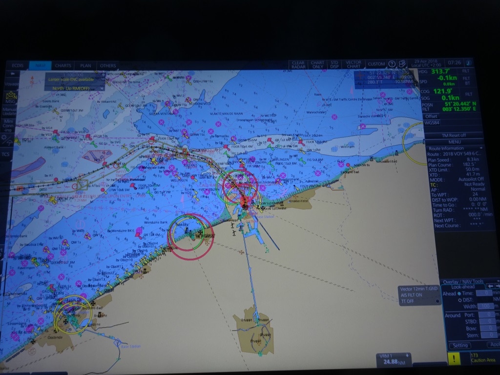
The light blue is the relative deep water of the North Sea (150 feet or more) and then where the light blue continues among the red and green buoys is where dredging keeps the wandering banks at bay. The big circles indicate various sorts of  lighthouses. The blue line straight down is the canal to Bruges for the smaller ships. We do not fit in.

Getting into Antwerp might take a long time compared to getting into Zeebrugge but also this port has its challenges. And that has to do with all the sand banks in front of the Belgium coast and the amount of traffic that goes up and down the North Sea, in and out of the Scheldt, and in and out of Zeebrugge port. The challenge with the sand banks is that they move. One of them, after which the pilot station is called, is called De Wandelaar, or The Wanderer, and that indicates already that it is moving all over the place. To avoid this there is constant dredging going on. In the approaches, but also inside the port itself.  For a while the main cruise ship dock was not accessible for ships with a draft over 8 meters. They had to go to the container terminal opposite. Not much of a problem as the port is big enough but challenging on a busy cruise ship day.  Today that cruise dock was occupied by one of those dredgers so we also went to the container terminal but one that is used for overflow and no containers were present. It did give plenty of space for our shuttle and tour buses.
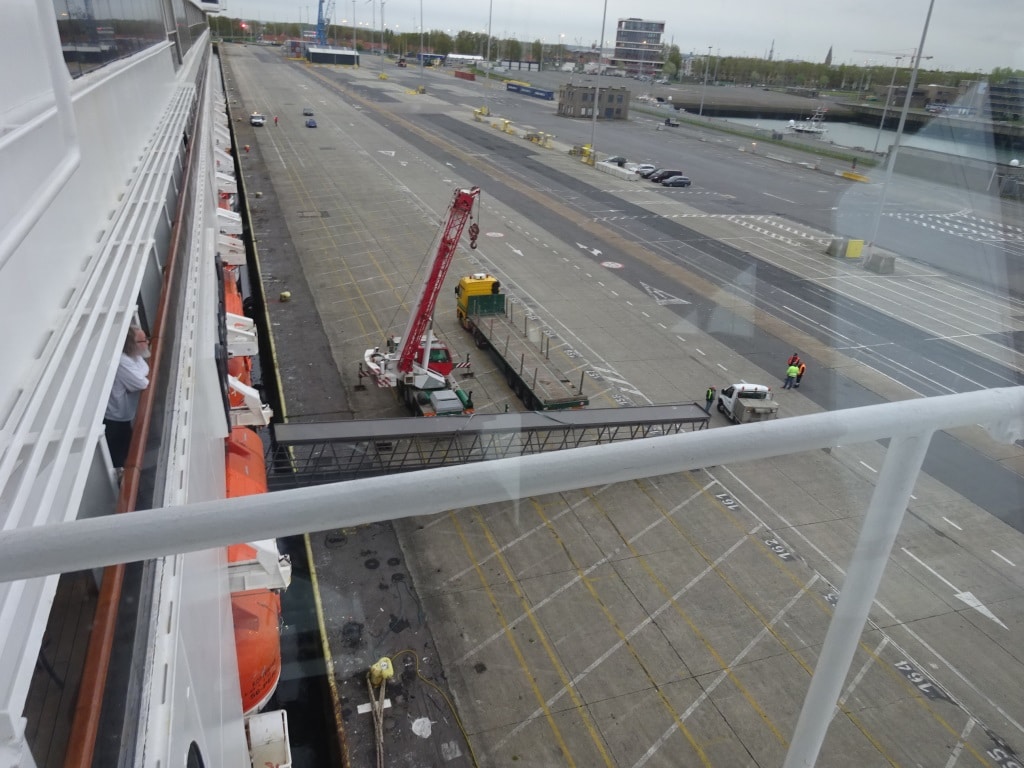
You do not dock at a container terminal for the view. But it does offer a lot of space for coaches and long gangways.  In the top right of the photo the church spire of Zeebrugge, about 10 minutes away with the shuttle bus.

Because of the sand banks, the pilot boards far out at sea and they even have an accommodation ship out there so pilots can sleep while waiting for their turn. Once they have completed their shift there is a fast boat that brings them back to solid land or more comfortable they can step off the ship that they brought in. That was the case today with our pilot; he was going home and the captain could not even tempt him with breakfast on board. Either he was in a hurry or he had had too many cruise ship breakfasts already in his life.

Although the pilot only has an advisory duty, most of the time he/she sails the ship in and gives direct orders (which are then acknowledged by the captain as being correct) to the bridge team. In a port like this where wind, tide and sandbanks can change by the hour that is the best way forward. Once it then comes to docking the Captain takes over again and parks the ship where pilot, harbor master and agent thinks it should go. If you go in and out of a port on a very regular basis, you can get a pilots exemption, so your ship can sail when it needs to, without delay. Most ferry captains have such an exemption as they are going in and going out as often as the regular pilots do. But you still need the local knowledge due to the moving sands, moving buoys and other things that Mother Nature can throw at you in these dangerous North Sea areas.

We will sail from here to Rotterdam and the weather is again going to be very windy. There is another weather front coming over which will bring a lot of rain and wind to the Netherlands. On one side I can live with it as I am going home tomorrow, on the other hand I hope that it will not affect the flights from Schiphol as my wife wants me home before cocktail time.
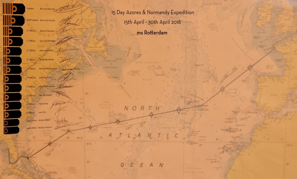
The Captain and his navigation team produced this North Atlantic Chart for the Guests. Marking the noon time position for everyday of the cruise. This was voyage 549 for the ms Rotterdam.

It is also the end of cruise 549, the ms Rotterdam’s Trans-Atlantic Cruise which has turned out to be quite a good one. We did have to cancel a port because of bad weather, the crossing was nice and quiet and we were just a bit unlucky with the rain during the last few days. But can be expected during a spring crossing. Now the ship will make a number of European Cruises, then make three Atlantic crossings between Rotterdam and Boston; and then start on August 25 a series of Canadian Maritime cruises to Montreal.

This is my last daily blog until 02 June. Then I will join the ms Prinsendam for three weeks and the first week is rather special as the ship will be celebrating its 30th. Birthday and we will visit her place of birth in Turku.

While I am on leave I am involved in something that seldom happens to a ship’s captain: opening an exhibition. As the Dutch King was not available, neither the Queen, nor President Trump, it was decided that I was the next best choice to do so. The exhibition is about the four Veendam’s the company operated and the predecessor of the first Veendam, the W.A Scholten. I was captain for four years on the Veendam IV (from 2004 to 2009) and thus I am somewhat qualified to be involved.

https://www.veenkoloniaalmuseum.nl/nl/in-het-museum/tentoonstellingen/veendam-in-de-vaart-1

I will post something on the blog once the exhibition has been opened.

Thus is it time again to say goodbye to all my regular readers and those who tune in on occasion. I hope that you found my daily ramblings, interesting and on occasion diverting and maybe even educational. I thank you for your support and interest.

And I promised a Dutch “Art Deco” on the HAL ships.
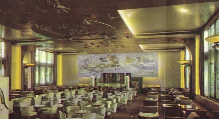
This is the Grand Hall of the ss Nieuw Amsterdam of 1938.  The decoration is much more subdued than on the Normandie but the coloring is not that much different.
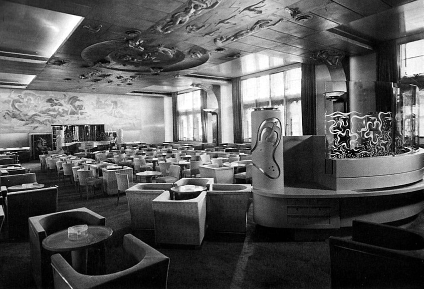
 

Again the Grand Hall of the ss Nieuw Amsterdam of 1938. Now in Black and White and seen from the other side. It is a mixture of styles. Some Art Deco, some Bauhaus and something what they called the “Dutch Style”. Still trying to find out what that is. Most famous is the ceiling with a number of nude sculptures, which gave quite a shock when the ship entered service. The ceiling still exists and is now owned by the Rotterdam Maritime Museum.
28 April 2018; Cherbourg, France.

On departure from Brest the Captain announced that we could expect some wobbly weather and some ships movement. And indeed 45 minutes after departure, when the ms Rotterdam pushed her nose into the North Atlantic Ocean, we took a few waves full on the bow and then moved about for a while. Then it became less and less until it was almost gone by 9 pm.  During a walk through the ship I had to go to great pains to explain to a few guests, why it the ship was moving in the first place and why it stopped moving in the course of the evening.  Well it all had to do with sailing around Brittany.

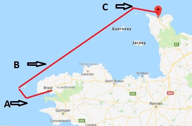
Our route from Brest to Cherbourg.

It all has to do with the way the swells are hitting the ship. When we left the port (see A) the swells generated by the storm (12 – 14 feet) were hitting the bow. That makes the bow go up and down and that is what we call pitching. The worst form is when the bow is lifted completely out of the water and then slams with an almighty bang back on the waves. That costs a lot of speed and thus ships often slow down to make it more comfortable and also as by on average they do not gain any extra mileage by keeping the slamming going. We were lucky because we were going to the North. So by 18.30 the ship had already made a nice course change to the North West and the ships motion was now between pitching and rolling. The stabilizers were doing their best and apart from the occasional lurch or sway, the ships movement greatly subsided. (See A to B)

We had even more luck because of the direction of the swells. By the time we turned to the North East (See B to C) we had the swell on the side and the stabilizers could take care. Why were we lucky? If the swell had been on the port quarter (half between the stern and the port side) then we would have experienced a cork screw motion. Then the ship not just rolls, or just pitches but does something in between which looks the way your laundry acts in the washing machine when the spin cycle changes. (If you have a front loader you will understand what I mean) This movement is very un-pleasant as it is hard to predict. We have that on all cruise ships that sail towards the Panama Canal when they are above Columbia. Here the swell generated by Trade Winds catch all the ships on the Starboard quarter and then they “corkscrew” all the way to Panama. Once we were above the top of Brittany (See C) we got the swell in the back but as the ship was sailing faster than the swell was running, the swell could not lift the stern up and the ship sort of surf boarded from there to the pilot station.

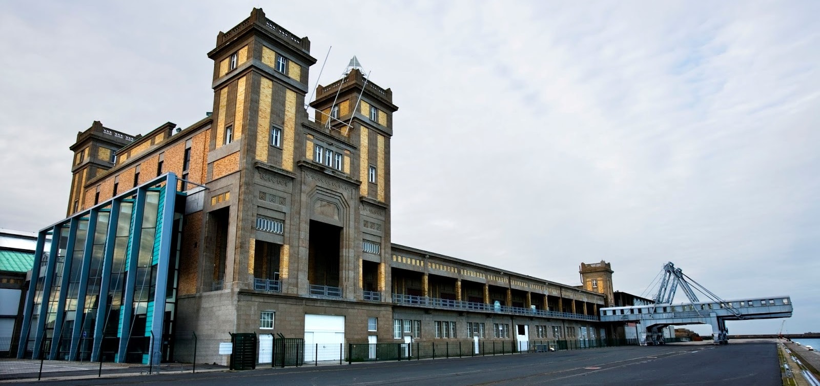
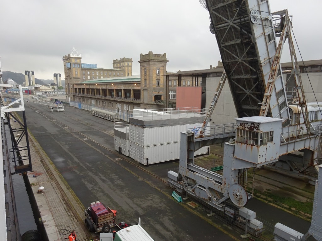
The Gare Maritime Trans Atlantique. The grey contraption to the right is the old gangway system on a rail track which would provide a direct connection to the terminal. Now we use shore gangways on platforms. Long gangways as the tide is considerable here in Cherbourg.

Cherbourg was still there; so were we happily docked shortly after 06.30 am., at the Cruise Terminal formerly the Gare Maritime Trans Atlantique.  It is now called the La Cite de la Mer with its Titanic (*) exhibition, its nuclear submarine and deep sea exploration Museum with a plethora of submarines and other submersibles.  It was a miserable rainy day and although the port had laid on a shuttle bus system to down town, a lot of guests opted for visiting the Musea in the terminal. A sort of disappointment was that the guests could not walk across the original shore gangways anymore and straight into the luggage hall of the 1930’s. The shore gangways have been condemned and need a lot of repairs and it looks like the luggage hall has not been morphed into the museum part.

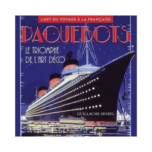
A book to dream about the good old days. And that for Euros 39.95.

I visited the bookshop which has expanded its book collection quite a bit (and that in the age of the internet) and they made my day. They had four books that I was looking for and had not been able to obtain via that same internet. (And they were cheaper than expected so that made by Dutch heart sing………) One book is really IT by normal book standards as it describes the great interiors of the Art Deco ocean liners of the 1930’s, such as the Normandie and others. Art Deco is my favorite art style and this book is a picture book. But one of those coffee table books you sit down with, with a good glass of wine in the hand, and just enjoy what those craftsmen and artists created in those days. I am enormously proud about Holland America Line but we never went over the top with the interiors the way the French did. I suppose we were “too Dutch for that”.

Tomorrow we are in Zeebrugge, gateway port to Flemish Belgium and cities such as Bruges and Brussel. Weather: Overcast with a chance of rain and temperatures around 52o F /12oC and a bit of wind in the afternoon.

(*) After leaving Southampton on 10 April 1912, Titanic called at Cherbourg in France and Queenstown (now Cobh) in Ireland before heading west to New York.

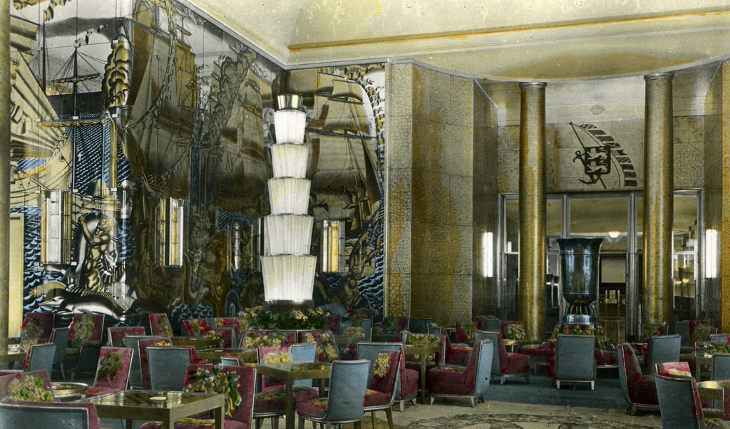
This is what we call Grand Art Deco; opulent and over the top. Tomorrow a photo of what Holland America Line did in the 1930’s.

27 April 2018; Brest, France.

Once the captain had made up his mind that he could make it to Brest before the storm would arrive, all engines were put on line and the ms Rotterdam raced over the ocean with a speed of over 23 knots. The Rotterdam is the fastest ship in our fleet and also one of the fastest cruise ships or ocean liners out there. We made it well ahead of the storm and we were tucked away timely in the old shipyard of Brest. It was nice to see the Dutch name “Damen” on a large shed on the dockside. Once the new building yard disappeared from Brest, the Dutch shipyard consortium Damen took part of the yard over for ship repairs and related as it has a 420 meter long pier (that is where we are) and a dry dock of the same length with a width of 70 meters. This means it can handle the largest ships. In the past it did so, having on occasion the largest oil tankers in the world coming. The French oil company ELF built three of those between 1976 and 1979, each over 500.000 tons and they had to dry dock on occasion as well. Brest with its deep water port was ideal for handling them.  All the larger cruise ships are parked at this dock as downtown can only take smaller ships with little draft.

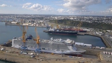
To give an idea about the scale. this shows the Norwegian Epic in dock and that is one of the big cruise ships out there. And she is not in the biggest graving dock. We were alongside where the black hulled cargo ship is.

The storm came over right on schedule. The wind breezed up to 26 knots around 6 am. (our planned docking time) and that would have made it very dubious whether we still would had been able to dock. In the course of the morning the rain clouds came followed by winds of over 50 knots. That is called a violent storm and those speeds are edging close to hurricane winds or force 12. The sort of winds you can lean into without falling over.  So the decision to go for an early arrival was a very good one, otherwise we would have had to spend a (bumpy) day at sea. The nearest sheltered alternative port is Cherbourg, where we are going tomorrow, It is also that 14 hrs. away and that means that we would have arrived in the late afternoon.  Thus this was much better. The town had laid on a very efficient shuttle bus system with bendy buses which stopped at 3 drop off points in town. Still a lot of guests stayed on board, not willing to brave the inclement weather. For those there were four little stands on the dockside selling local specialties and several Ladies sent out their Knights in Shining Armor to get the cookies and some other local things, while remaining themselves safely out of the wind.

At the west side of Brittany is Isle Ouessant. Ships have always tried to cut the corner here, but no more. Now you follow the “highway at Sea” further out.

The distance to Cherbourg is about 245 Nautical miles and the ms Rotterdam has to fly again tonight to make that schedule. Because of some oil spill and other shipping disasters in the past the ships cannot hug the shore line any more, unless you are really local traffic, and thus we have to go further out and follow the Vessel Traffic Separation Schemes (VTSS) which keeps everybody at a safe distance from the rocks. There is even a special VTSS for tankers, which keeps them even further away from the rocks. Understandable and well appreciated but it does make the journey quite a bit longer.

Cherbourg has a safe and deep water harbor and is very much sheltered from the westerly winds, such as the one we had today. That makes the port a favorite port for a plan B. And they do get a lot of extra business from that plan B. Especially from the ships that have to cancel Guernsey and/or Jersey. If you arrive at Guernsey at 7 am. and observe that there is too much swell at the anchorage (the anchorage is only well protected from winds from the west and south west) then with full ahead you can be docked at Cherbourg around 10 am. The locals are completely geared up for this, and they get tour buses, shuttle buses and authorities all lined up in that 4 hour time window. I have not experienced many other ports who can do that.

The Ocean Liner Terminal in Cherbourg. In the 1930’s the large ocean liners used to leave from here.

Tomorrow we will arrive at 07.00 hrs. but I wonder how many people I will see when I go for breakfast at 06.30, as we will have a wobbly night while sailing along the coast of Britany. The storm today has whipped up the waves considerably. I am looking forward to Cherbourg as we are docking at the old North Atlantic passenger terminal which the French in a very nice way have converted into a Museum with a Titanic exhibition and a nuclear submarine. But it also has (at least last time it was still there) a nautical bookshop.  For one who lives in England it is very hard to get French books (even via amazon) so if the books do not want to come to me then I will have to go to the books.

Weather: chilly and overcast with a good chance of rain. Temperatures 120C / 54oF but very little wind.

26 April 2018; Bay of Biscay, Enroute to Brest, Day 2.

Today we had the silence before the storm. We are expecting a lot of wind tomorrow and the captain has decided to go pedal to the metal to Brest and dock as early as possible. If not then there would be a good chance that we would arrive together with the storm and then we would have had to cancel the port call. In agreement with the local authorities the current” read” on the weather is that if we are safely docked before 04.00 hrs. we should be ok. So the ms Rotterdam is aiming for the Brest pilot just after 2 am and to be all fast before 3 am. And then it can blow as much as it wants.

The wind is increasing while the system is slowly moving into the English Channel.

At this moment (1600 hrs. GMT) the depression is slowly approaching and is about 450 miles away from the French coast. The first strong winds are expecting to hit Brest around 04.00 hrs. and then the worst is expected between 10.00 hrs. – 15.00 hrs. with 40 knots wind gusts from the West. After that is should diminish very fast. 40 knots of wind is not a big deal for a ship to be in while at sea or while safely tied up in port but it is too much to have it blowing that hard when you want to dock. Hence our early arrival. And by the time we leave around 17.00 hrs. the wind should be manageable again.  Then we sail to Cherbourg and there we should have a nearly wind free visit. The “silence after the storm”.

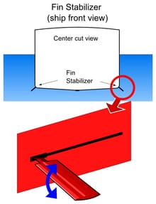
Stabilizer diagram. Thank you Wikipedia.

Same as today; the Bay of Biscay is nearly wind free. Just a slight ripple lies over the waves and the under laying swell. The ship is moving a little bit and the stabilizers are getting a very good workout. There is a long rolling swell coming in from the North West. From the part of the North Atlantic Ocean where depression after depression is still moving from Cape Hatteras to Northern Europe.  We have about 3 meters running and it is a long running swell, nearly full on the beam and the stabilizers are not always able to cope with every movement. That has nothing to do with the quality of the stabilizers which we have here on board the Rotterdam but the principles of the system.

Stabilizers are controlled by a gyroscopic system. A gyroscopic (basically a fast turning ball) works on the principle that a fast spinning ball is always trying to settle on a flat horizon. Because of this you can use it to measure the difference between that artificial horizon and the angle that the ship has in relation to it. Once measured you can send a signal to two stabilizers or four, (The Queen Mary 2 has two sets due to the weight of the ship, the ms Rotterdam has one set) and they then counter act the rolling motion.

They create lift in same way an airplane extends its wings for taking off or landing. Apply that lift opposite to the way the ship is rolling and you can reduce the roll. But as the gyroscope has to sense the angle and then send a signal to the stabilizers it is always slightly running behind the facts. Also if there is suddenly an extra high or low wave hitting the ship, it will react to it after it has measured the angle and then let the stabilizers go to work. They are hydraulic and that takes time as well.

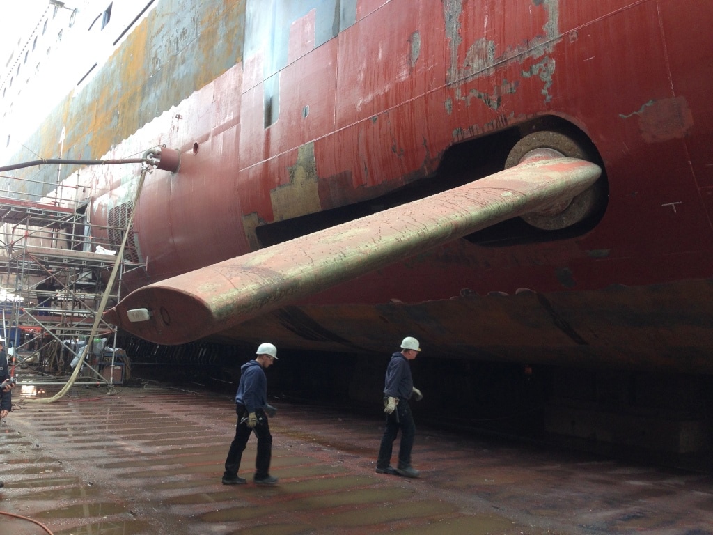
The stabilizer of the ms Rotterdam. Seen here in drydock in 2015 before it was painted,

Based on this concept the stabilizers establish a sort of average working mode against the regular movement = rolling of the ship =. Hence it is considered to do good work if the dampens out 90% of the roll caused by the waves. If the ship would roll 5 degrees without, then the movement will be reduced by 90% to about 0.5 degrees. An unexpected higher wave will throw the system off a little bit until that movement is taken into account for the averaging.

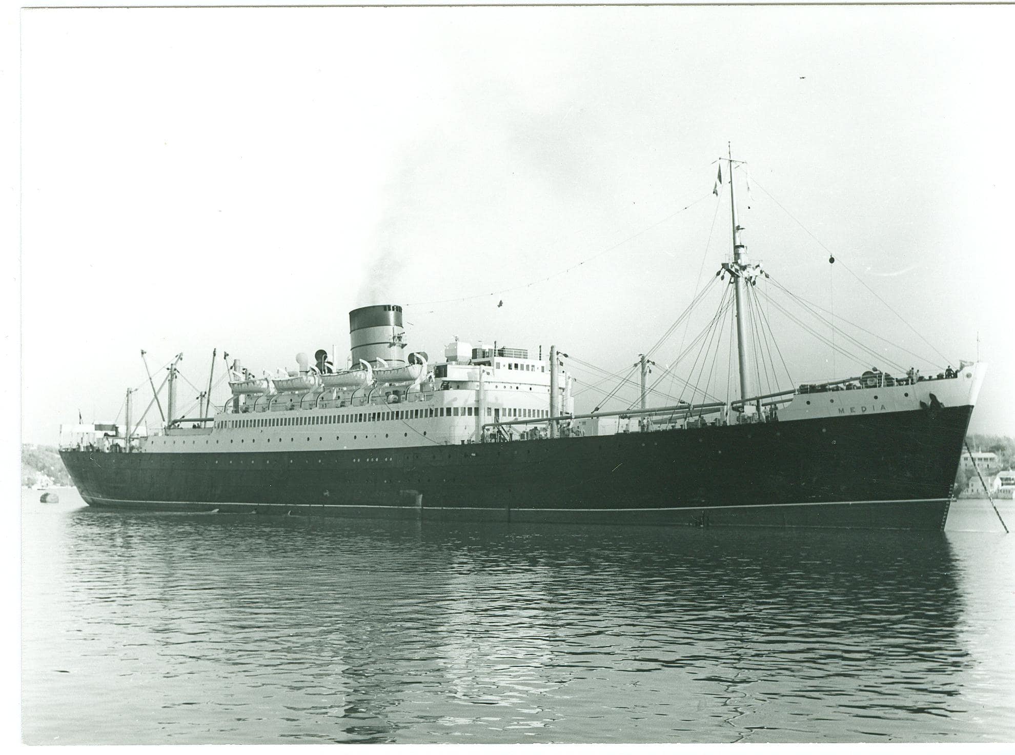
The first stabilizers were proposed in the 1930’s but they showed up on the first passengers ships in 1951. The Media and the Parthia of Cunard, passenger – cargo liners were the first to have them installed, more as a test than anything else. But it worked very well. Then it very quickly became a standard feature of all the new ocean liners and cruise ships built.

The ss Media of Cunard Line. A passenger Cargo Combi liner for the intermediate service. (Photo Courtesy: Mrs. Robina Herrington)

I do not think we had a single ill guest on board because of the movement as all the activities going today were choc-a –bloc with people. Even Rummi-Cub was standing room only and that is considered a minor event among all that is going on.

In the meantime the good ship ms Rotterdam is racing through a quiet Bay of Biscay with an average speed of 23 knots. It is doing so on a more or less straight course and the more or less is caused by whales who are getting in the way. Luckily they are not in large groups and thus the navigators can easily dodge them.

Tomorrow we are in Brest and it will be a windy day with quite a bit of rain in the planning as well.

25 April 2018: Enroute to Brest, France, Day 1.

Departing Ponta Delgada is always a sort of non-event. Give the ship a kick ahead, make sure the pilot gets off as soon as possible and then sail straight out. Because the island of Sao Miguel makes a sort of nick in the middle we have to sail for a little while on the slight south easterly course and then we can turn to the North East once clearing the island. We followed the Royal Princess out and then left her to starboard. She is going to Lisbon and that is more to the south than Brest and thus we are heading on a steep North Easterly course directly for our next port. That keeps us well clear from our next weather hot-spot, the Bay of Biscay. For those who think that the weather is only bad in the Bay; that is not correct, it can be bad on the whole ocean, it is just then a little bit worse in the Bay itself. Why is that?

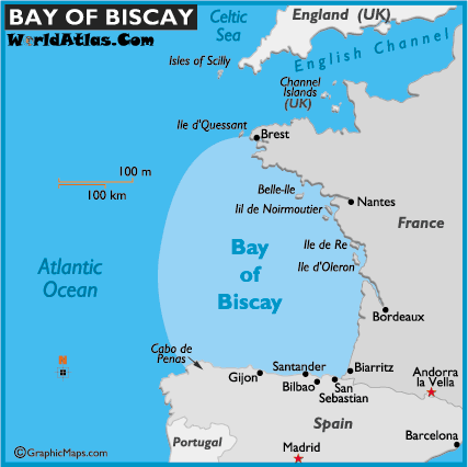
Really it is much more than a bay. It covers more or less the whole west coast of France. The bad bit is the South East corner starting at Cabo de Penas. (Courtesy map Worldatlas.com)

Because the storm rolling in from the north Atlantic gets in stuck in this corner called the Bay of Biscay. The wind can continue overland but not the waves. They are forced to run ashore, have nowhere to go, bounce back and build up in height. So the ripple that wants to continue “rippling” through the ocean cannot do so and some of its energy ripples back again, and hits the ripple coming in next. This gives a sort washing machine motion with very high waves which are not all of the same length and same height and that can make for a very unpleasant ships movement if you get into a storm here.

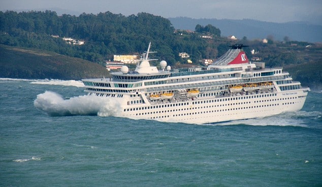
Not the entire bay is deep and over shallow area’s the waves can build up even more, sometimes resulting in a port being closed. Then even during good weather, the swell of a past storm can still remain and create a very unpleasant situation when you leave the port of La Coruna (or A Coruna in Spanish).  I have included below one of the very famous photos of the Fred Olsen cruise ship Balmoral who left La Coruna and met these high and irregular waves.  There is not much you can do about it except either stay in port and wait for the swells to subside or sail against the waves very slowly so you ride them but not hit them. I have done that in the past with the ms Prinsendam a few times where we just sailed out of port with 3 knot speed until we came in deeper water where the swells were less steep. Once in a bit of deeper water you can start edging up the speed and try to find the right balance between the ship not moving too much and still getting some mileage made to get to the next port.

Very nasty if you get into something like this. Important to sit down, hold onto your drink and wait for deeper water. (Photo courtesy via www.captaingreybeard.com)

As a result of this nasty weather we see it often for the French port of Bordeaux that the pilot will arrive by helicopter because the seas are too rough for the pilot boat to come safely alongside. Sailing to Bordeaux you need to enter the river Gironde and there where the sea and the river meet, things can also be extremely nasty at times. Only smaller cruise ships go up river to Bordeaux as they have to fit under a bridge and be able to turn upstream for the downward journey again. Somewhere in the year 2009 in the blog archives you will find my exploits about going to Bordeaux with the Prinsendam. You go up the river with the rising tide and you can only come down again when the flood brings enough water to the port and the ebb has not taken too much water away yet. And then you have to go over the bar at the estuary back into the Gulf of Biscay.  Luckily it is not all bad and in the summer months and into early autumn it is normally quite peaceful here.

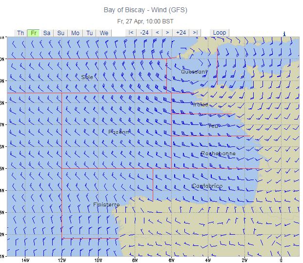
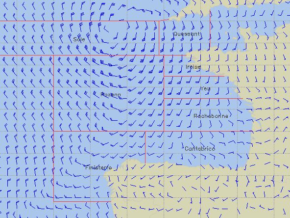
This is the weather forecast for 27 April which shows a small but intense pressure system laying at the edge of the English Channel. It will cause some windy weather in Brest. Unless it clears up or fills in tomorrow.

Our course keeps us will in the open area of the Bay of Biscay and even when we approach Brest we are not in the really “exciting” area of the Bay. Our course keeps West of Cape Finisterre on the North West point of Portugal and then we will approach Brest in open waters, directly heading for the pilot station. At the moment it is extremely calm in the Bay and will remain so for the next two days. But the weather gods are not doing the same off the coast of Brittany. The day we are in Brest a small depression is scheduled to pass over bringing a very windy day to Brest and then a calm day the next day for Cherbourg.

Ponta Delgada; Sao Miguel, Azores.

It was any early morning arrival and we had to wait a little bit as apart from the Zenith we also had the Celebrity Silhouette in port and that brought the total of cruise ships up to 4 and the total of ships up to five as there was also a small cargo ship present. But we were still docked by 07.00 hrs. exactly on the schedule as envisaged by those who made the cruise brochures.  As all the guests on the various ships were looking at a near perfect cruise day, there was a steady flow coming from all the gangways and moving into coaches or walking into town. It was a sunny day but it was not too warm and it was not too windy, it was near perfect. (It would have been perfect if I had had time to go ashore as well, but we had a General Emergency Drill today).

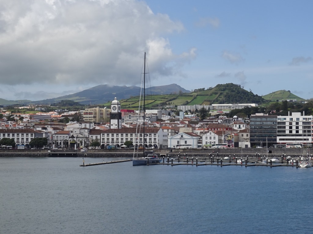
Ponta Delgada as seen from the ship. Wonderful place to be; friendly people and you can pay in euro’s.

Today the weather was running ahead of its own schedule and the increased wind that was supposed to come through in the afternoon, came through in the morning and died down again by early afternoon. At the same time it veered to the North East from the South West and with the North Easterly wind came very low clouds which collided with the island at the east side and brought rain there. Not that it bothered us we just saw it after departure when our route turned into scenic cruising with a green and lush island on the port side and whales and dolphins on the starboard side. No wonder that the Azores are so popular with the cruise guests.

The Azores have been a popular place for cruise ships for a long time. And the constant battle has always been between Funchal on Madeira and Ponta Delgada on Sao Miguel; about who was the most wanted and enticing island for cruise guests. Both islands are part of Portugal so it is not about international rivalry.  That could be the case between the Portuguese Islands together and the Spanish Islands such as Canaries which are not that far way. Before cruising became really popular, there was already a steady trickle of ocean liners and passenger ships which filled their winter downtime with an excursion to the warm weather islands. In most ports a breakwater/ dock had been built shortly after the turn of the century as running tenders in these ports was nearly impossible even during perfect weather due to the long ocean swell rolling in. Even today, with very good weather conditions, we could still see the waves crashing ashore just outside the port.

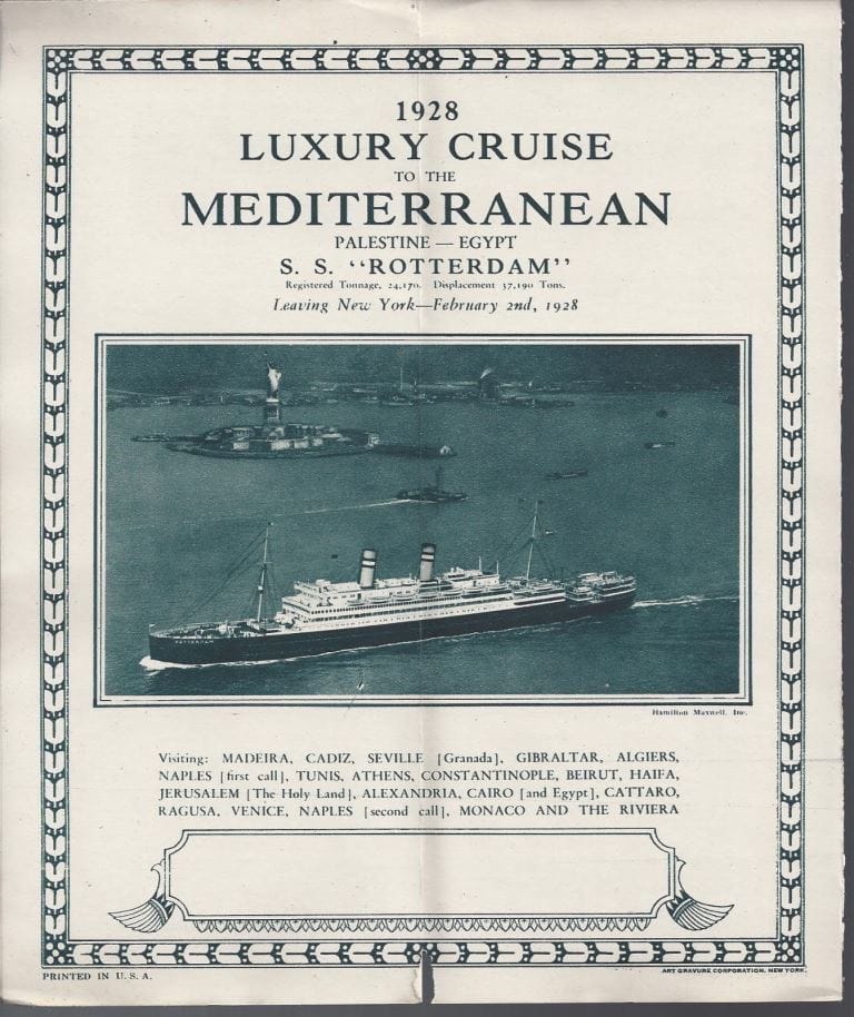
A cruise of the ss Rotterdam in 1928 calling at Madeira (Funchal) as its first port after leaving New York.

The Germans and the English were the most eager to visit these ports, no doubt due to the fact that they could reach a bit of sunshine without having to sail too far and with a climate which was /is very temperate due to the regulating North Atlantic sea temperature (Never too warm and never too cold). So you could make these cruises with ships that were not really designed for cruising and definitely did not have any air conditioning. Holland America showed up on occasion; when one their ships made the annual spring cruise to the Holy Land before the First World War when they then called at Funchal. Not because of the difference in port quality, as both ports are nearly identical, but Funchal had better coaling arrangements and that was for the old coal fired ships of extreme importance. The Holland America Line cargo ships called for coaling mostly at Las Palmas on Gran Canaria and although I do not know the real reason for it, it looks like that it had to do with reaching their limit of coal supplies on board and then to be able to load as much as possible for the remainder of the journey.

After the 2nd world war, when cruising picked up again, and the ships were now oil fired, they called at the ports depending on how the cruise was setup. Same as we still do today. Next time when the ms Rotterdam is on its crossing, it might as well call at Funchal or Las Palmas instead of Ponta Delgada.

We will now have two days at sea to cover the distance between Ponta Delgada and Brest in France. Weather still looks good we just have to see what the air circulation off the African coast is going to do.  For the moment it is perfect. The high pressure system we were sailing though yesterday is on the move north and exactly following our course line. So we will keep nice weather and it might also keep a nasty swell away from us. Otherwise it will get a bit wobbly on Wednesday.


23 April 2018; Enroute to the Azores, Day 4.

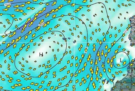
The weather worked out as predicted and this morning we woke up to a windless surrounding, courtesy of sitting in between all the various wind directions generated by the High pressure system which we are sailing through at the moment. That also had an effect on the sea and swell. This time the word confused seas was completely appropriate. As the winds around is all from different directions (see the wind chart of yesterday), those winds also generated waves and swells for all different directions. When looking outside around noon time, I recognized a long running semi high swell (6 feet) from the North West, a long running lower swell (4 feet), from the South West and a bit of wind from the North East which did its best to flatten off the tops of the waves even more. Sometimes these swells enhanced each other and we saw 10 feet and sometimes they cancelled each other out and the sea was flat between two subsequent waves. It will remain confused until we come very close to the Azores  when we near the North East side of the current High pressure system and then the winds will become Westerly. But not much more than a very gentle breeze and we might not notice anything at all in port as we will be docking deep in the port of Punta Delgada which is protected against westerly winds by a mountain ridge.

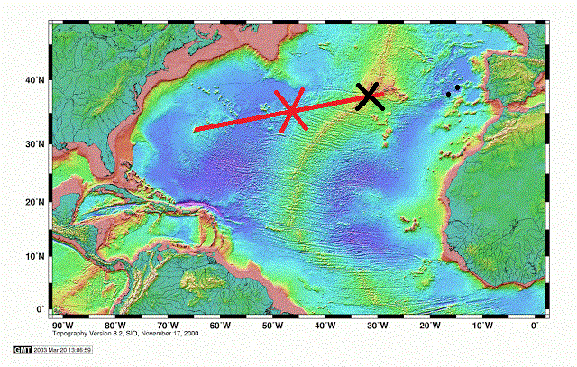
We are now at the black cross. The water is a lot more shallow as we are nearing the Azores plateau.

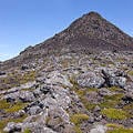
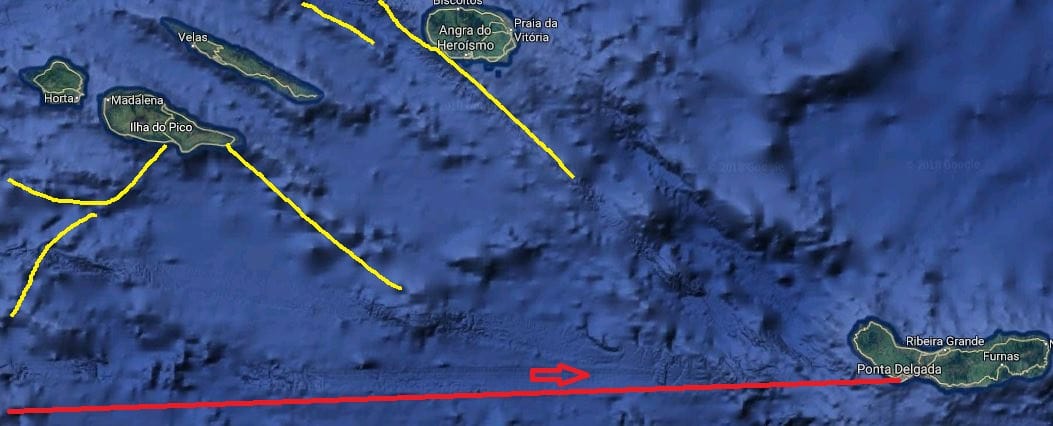
For our under water happenings we are now sailing right on top of the midatlantic ridge. And as there are three plates meeting here there are numerous cracks as part of and next to the main Atlantic ridge. That created and is still creating the plateau on which the Azores are located. Off the plateau the ridge is about 10000 feet below water; at Pico (one of the islands of the Azores) it has created a mountain peak = Pico, which goes 7700 feet up into the air.


The mid atlantic ridge off the Azores.

The mid atlantic ridge creating Pico mountain.

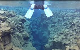
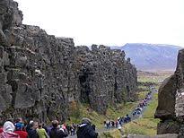
The Ridge Walk as is possible in Iceland. Every year the path is supposed to get 2.5 cm. wider.


So the ridge is not always under water. In Iceland you can walk through it, in some places you can swim just above it, in some places it is far under water but here at Pico it goes up in the air and has created the highest mountain in the Azores and the highest mountain of the ridge itself.

The Azores, the northern islands. The underwater mountains, hills, valleys and ravines under water show a very fractured landscape.

We stayed about a 100 miles away from the island of Pico and thus we could not see it. Our straight course line only converges with the Azores by the time we put on the brakes at the pilot station. That is now all arranged. The Royal Princes will be 30 minutes behind us and we are aiming for a 05.30 pilot station. Ahead of us is the Zenith which should be there earlier but we have been advised that we might have to wait a little bit. Still she should not be much of a challenge as she is going to the downtown berth (courtesy of making regular calls against our one off) and both us and the Royal Princess are docking at the inside of the Breakwater. We will swing around on arrival and then back all the way in to the end of the break water. Which is nice as it reduces the walking distance to downtown considerably. The Royal Princess will then come in after us and will use the remainder of the pier.

Weather for tomorrow: Temperatures, 17oC / 72oF sunny and a very gentle breeze from the west.  Should be a perfect day for the guests going ashore and to go sightseeing. Although Punta Delgada is also a perfect port to do nothing and just sit on the boulevard to watch the world go by.

22 April 2018; Enroute to the Azores, Day 3.

The ship awoke today to a beautiful sunrise at 07.00 hrs. Right in front of the ship and in the round sun we could see a single black spot and that was the Regal Princess. She was still some miles ahead of us but we expect her to stop an engine sometime this morning to adjust for her correct ETA. And then we will overtake her as the plan is still to dock first.   The wind has reduced somewhat and instead of a relative wind wind force 8, we now have a relative wind, wind force 5 on the starboard side.  Life is never perfect of course, as we are now moving away from the Gulf Stream we have a different balance between the seawater and the air temperature. Both are now almost 19oC. or 66oF and just far enough apart that the moisture in the air can condensate somewhat. As a result it became quite hazy later in the day and the haze blocked out a strong sun from shining onto the deck. But the swell has mostly disappeared and the ms Rotterdam is steady as a rock again.

These are weather maps we like. All the nasty red stuff is disappearing. (Courtesy www.stormsurf.com)

Early tomorrow morning we should arrive in the area which is dominated by the Mid-Atlantic Ridge; although we will not see very much of it. At the moment we have almost 11000 feet under keel, just less than 4 kilometers, and that also reduces the chance of running aground considerably. As the new land ridge is formed constantly it would need an awful big disruption to build up enough lava to create a pinnacle that would go up 10,000 ft. Where is this lava coming from? From cracks in the earth’s crust. Everywhere were there are volcano’s, the earth’s crust is either very thin or there is a wide crack which lets the lava escape.  In the old days people took one or more volcanos just for granted without really knowing why they were there. That all changed when a gentleman called Mr. Wegener popped up. He is now mainly remembered for his theories about these cracks and related earth’s movement although his main focus through life was meteorology and geophysics. Focusing on Greenland where he also died 50 years old while on a very cold expedition.

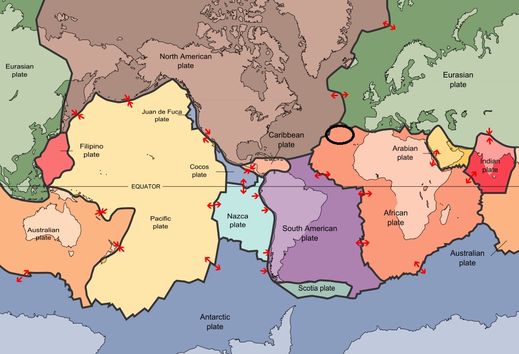
The way the world looks like if we would only look at the natural – volcanic- boundaries. We and the Azores are in the black circle. (Diagram courtesy: Wikipedia)

In simple terms he figured out that there was a correlation between all these volcano’s and the way they were patterned around the world. He tried his whole life to get his theory accepted but as is not un-usual, when something truly revolutionary is proposed, not many people and scientists believed him. It took well into the 1950’s before others had accumulated enough much evidence for him to be recognized as the father of the Tectonic Plate Theory (and reality)

What is it; basically the whole outer crust of the earth is made up of several plates and they move. (About 2.5 cm a year) They do move because they are pushed by the lava coming out of the depths of the earth and this is helped by one plate moving over the other and the other one then being pushed down into the earth again. Becoming fluid and then starting the cycle again somewhere else, depending on the magna flow deep in the earth.

The mid Atlantic ridge is the location where the North American Plate surfaces and is going westwards and the Eurasian plate which is going eastwards. Where we are now, near the Azores, the situation is even more complicated as it is the region where those two plates are also meeting the African Plate. This is called a Triple Junction. Hence there is good reason to expect volcanic outbursts on the Azores and on any other islands in the area. (Madeira or the Cape Verdes) The Volcanos on the Azoric Islands have been exploding on a regular basis through the centuries and if there is no sign of a volcanic eruption then there is always the danger of earth quakes. The plates which are sliding with 2.5 cm. a year do not experience this in a friction less way. It is more a “hop” and a “stop”. The hop is then the earthquake when the earth really moves. The last major Volcano outburst in the Azores was in 1958 but (light) earthquakes happen with great frequency every year. Most earthquakes happen under water and that means we do not realize it and feel it while on the ship. Those earthquakes can create a Tsunami but even when a ship would be sitting on top of it, you would not feel it as a Tsunami is a pressure wave which only “bundles” its energy when it comes in shallow water and it has nowhere to go but up. There is no Tsunami or Earthquake alert out for the moment so I assume we will be ok for our coming visit. No reason to be alarmed, the people in San Francisco have also not run away since 1906.

Weather for tomorrow: We are now sailing into the Centre of the High Pressure system, so the wind should shift from the South, to the North and then fall away. If the system does not move there should be a period of hardly any wind and only confused seas to observe. Temperatures should remain the same. They are too close it might remain hazy but if the sea water temperature fluctuates a little bit we could have a nice, clear and sunny day.

The way the wind looks like around us. We are almost in the H of the weather system and thus we should see the wind changing. (Courtesy: www.stormsurf.com)

21 April 2018; Enroute to the Azores, Day 2.

Well, we did not go faster than the weather and we did not go slower than the weather. And thus we woke up to a rainy morning. But there was change in the air with the following wind slowly moving at bit to the South resulting in strong winds on the starboard side of the ship (a relative wind force 8: 20 knots from the ship and 12 knots from Mother Nature). We have some avid walkers on board who are either doing 1,2,3 or umpteen miles a day and each time they came around the stern they got the full southerly wind in the face until they had made the corner. Not pleasant you would think but as one Lady said, leaning against the wind also burn calories. I suppose that is true, I just do not have any idea how many calories that might be.

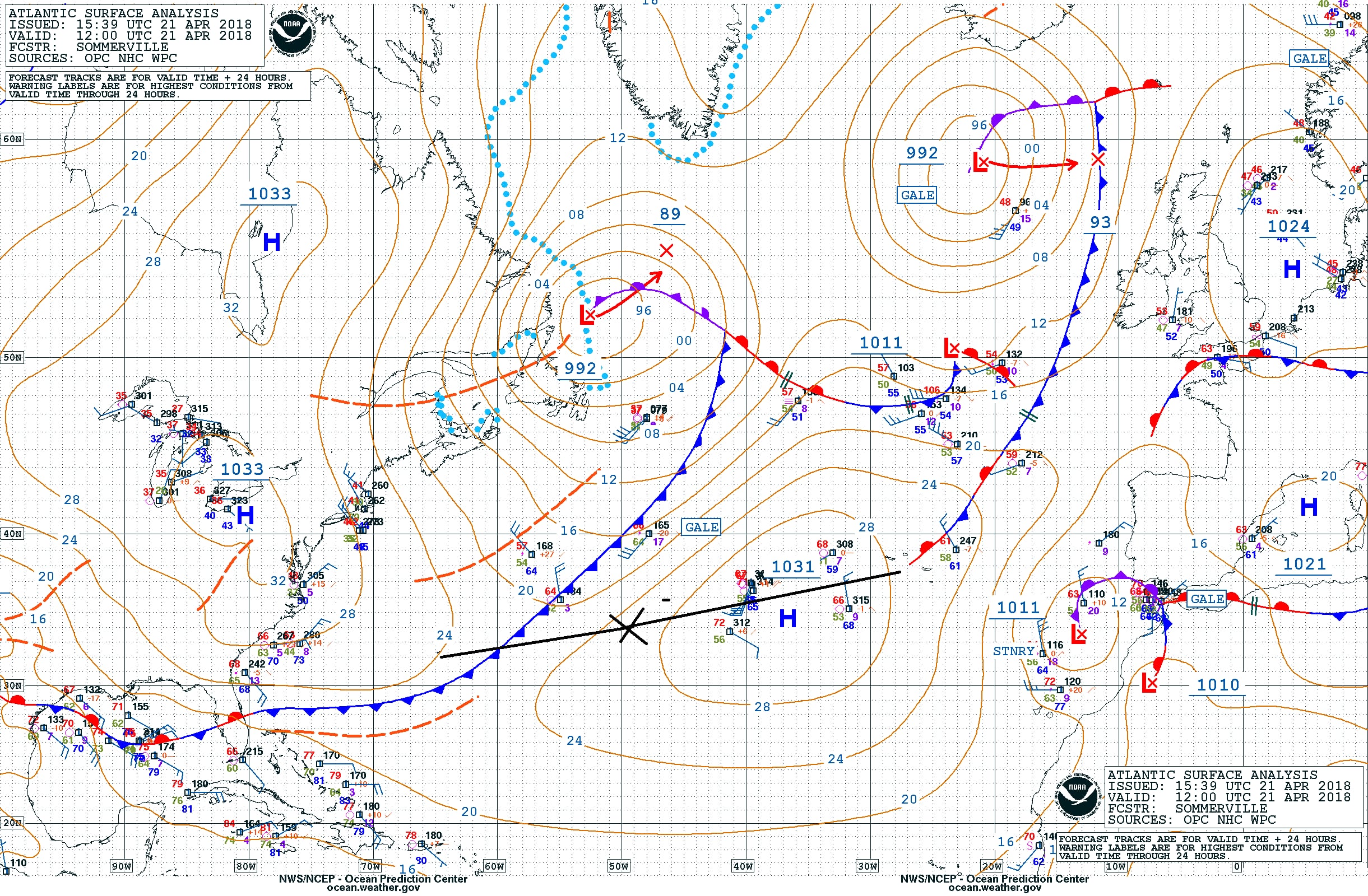
The weather chart for today. We were at the X at 1600 hrs. ships team and the frontal system is being pushed north by the High pressure system. That should mean that it will remain sunny and that the wind will diminish in the near future. (Courtesy NOAA)

I mentioned yesterday that there would be at least 3 cruise ships in port and that the Regal Princess was going to arrive shortly after us. Although it being Saturday, the local authorities had been thinking and have asked the captain to arrive at least 15 minutes earlier to spread the congestion a little bit. Of course he was willing to do that but it meant bringing an extra engine on line, while the following wind had just made it possible to switch one off as we were making good speed. Now we have to catch up 15 minutes first and then we can stop the engine again. A sort of driving faster to get there before the traffic jam. I try to do that on the motorway as well, you know that a certain junction will clog up at a certain time, so you try to make sure you are past that point before it happens. Whether it was speeding up of the ship or not but shortly after the sun came out and the rain clouds faded away.

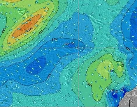
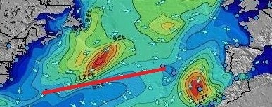
The wave and swell chart of today. I have cropped out only the significant part for us as these charts cover most of the North and South Atlantic. As you can see we are just skirting the 12 feet wave edge and are in the 6 to 8 feet. Depending on how fast this wave field moves, we will get less swell or it will remain the same. (Courtesy: www.stormsurf.com)

To the north of us is a nasty weather system and some of its swell rippled down to the south and we picked up a bit of it increasing the average height from 6 to 8 feet. It merged on our course line with the swell generated by the Southerly wind and that gave on occasion a confused sea and a strange wobble of the ship. But we are still doing extremely well with the weather as the ship only moves on occasion. If the swell goes over 10 feet then we could get some regular rolling or pitching but that has not happened yet. It is always hard to predict what will happen in the Mid Atlantic but for the coming days we might be able to keep the swells low and the ships movement very small.

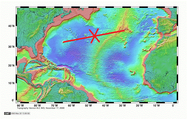
As far as Wild Life is concerned it is very quiet. The wind and the rain do not help I suppose but all day I have not seen any birds or other animals what so ever. While normally this is a good area for “catching” exhausted small birds that land on the ship and who then happily hitch hike with us to the next port. Thus at the moment below water things are more interesting than above. Yesterday morning we left the Bermuda shelf behind and the water went very deep. Contrary to popular belief the ocean bottom is not flat even if certain areas look flat on the chart. It is just relative; if you have depths of 6000 meters or 18000 feet, then a height variation of 500 feet is not much. Still 500 feet is a nice size hill on dry land. If we could drain away the water around Bermuda then Bermuda would be a very big mountain with very steep curved sides ending in a sort of pancake top with a few hills sticking out and those hills being the dry land of Bermuda. Once we fell of that shelf, that pancake, the water went deep, very deep.

A chart of the bottom of the North Atlantic. We are roughly at the cross and that green spot behind us north of the red line is Bermuda. It will take another day before we are close to the center of the North Atlantic Ridge. (Courtesy: Unknown Maker on the Internet)

We will keep sailing over very deep water until we come to the Azores. Before that we will cross the Mid Atlantic Ridge, there were the European side meets the American side with a huge crack in the middle. More about that tomorrow. The Azores are located on a sort of side platform which is attached to the Mid Atlantic Ridge. All caused by extensive volcanic activity. The Azores itself are quiet at the moment but all along the Mid Atlantic Ridge here is a lot of volcanic activity deep under water.  The minerals and other nutrients which are released here form the environment for lots of wild life and many new species are discovered. Which is now possible because unmanned submarines give the scientists finally the option to explore the great depths without having to be there in person. They say we know more about Mars than we know about our own ocean and I would not be amazed if that was correct. By the way for those guests who are interested in Mars and other planets one of the lecturers on board is explaining mankind’s exploration which goes up instead of down.

Tomorrow is another day at sea, and then one more and then we are in the Azores. Weather for tomorrow: again it is a wait and see game. How fast is the outside weather going? If we keep up then the gale to the north of us will not cause too much of an issue. If we go slower, we might feel more of the waves that it is sending down to the south, towards us.

20 April 2018; Enroute to the Azores, Day 1.

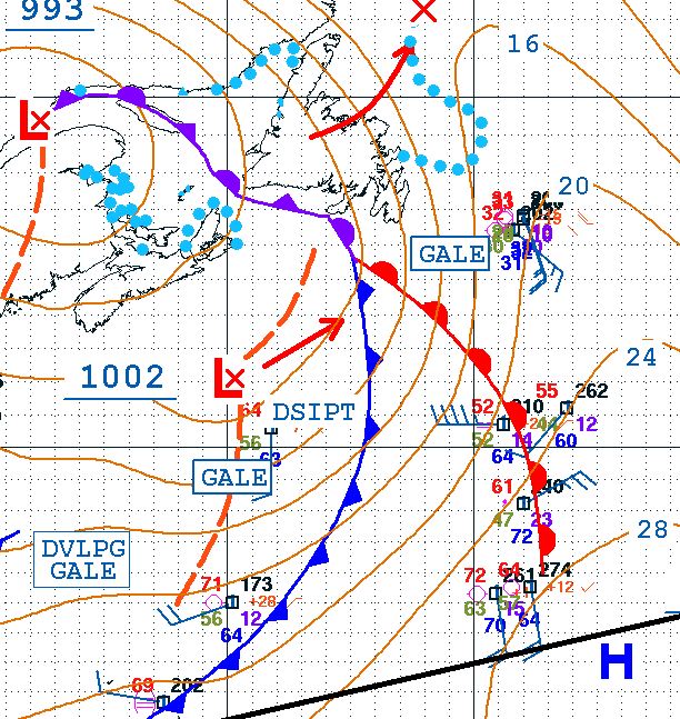
When a weather system comes over, it normally follows a standard pattern. Wind is from a certain direction which then shifts the moment the front passes. Normally that front looks a bit like an R. As you can see from the cut out of the weather chart from yesterday, that weather front laid over Nova Scotia but its tail came halfway down the North Atlantic. Red indicates a warm front and blue a cold front and they form the boundary between two separate regions of weather. The difference between cold and warm does not need to be that great. 10oF or so if often enough, especially in regions where there is the influence from the Gulf Stream.

The black line at the bottom is our course line so we are at the end of the tail of this weather front. Along the rim higher up there are developing gales and dissipating gales but we are far enough south. The frontal system can be seen again at end of the blog on the Sat. Photo.

When we left the shelter of the Bahamas a cold front had just passed by and then the wind changes as the High pressure – low pressure locations are different on each side of the front itself. Thus for us the wind shifted to the South West while we sailed north east towards Bermuda. And because we had a high pressure system in the back and a low pressure system ahead of us the wind blew the clouds away and smoothed the waves and thus we had beautiful day at sea and later in Bermuda. There the wind started to increase, indicating a new front coming over, which did so during the night. Now we are in that frontal system, right between the two legs and so we get a lot of rain as the warmer air condensates all the moisture once it gets hit by colder air. If this weather front keeps doing what it is doing at the moment, it will start to pass by late afternoon and then we will have a nice sunny day tomorrow. Because the winds keep opposing each other with each frontal system, the wind does not get the chance very much to push up the waves and thus we are having a steady ride.

We are not the only ship here, the Regal Princess has followed us from Bermuda as she is also going to Ponta Delgada in the Azores. At the moment she is scheduled to arrive 45 minutes behind us but the captain could always change his mind. The strange thing for everybody on board is that although the ship is supposed to arrive after us, she is overtaking us. This has to do with different engine configurations. The ss Rotterdam has five Sulzer 16 cylinder engines which can produce 25 knots if needed. For 16 knots we only need two engines and for 19 knots only three engines. As power versus speed is not linear we need a fourth and fifth engine just to deliver those last 6 knots going from 19 to 25 knots. While one engine could take us from 0 to 6 knots in the low speed range.   At the moment we are making surplus speed, because we have current and wind behind us. We started out on 4 engines and we will stop an engine as soon as the remaining engines can maintain the average speed needed.

The Regal Princess has four engines (2 x 12 cylinder Wärtsilä 12V46F and two 14 cylinder Wärtsilä 14V46F) This means that when they will stop an engine it will be at a different average speed to maintain. Their four engines deliver a maximum speed of 22 knots, and will reach the “3rd engine stage” at a different time. Then we will overtake her again to be first at the pilot station, unless they change their ETA. (Estimated Time of Arrival)

We will also meet the Zenith of Pullmantur in Ponta Delgada and then the Regal Princess so will sail together with the Zenith to Lisbon while we head north towards Brest in France.

For us at the moment the question is, will the band of rain that came by this afternoon rain out, or ep a higher speed than the ship, or go slower than the ship and will we will have a nice sunny day. The weather forecast says yes; so we also hope for yes.

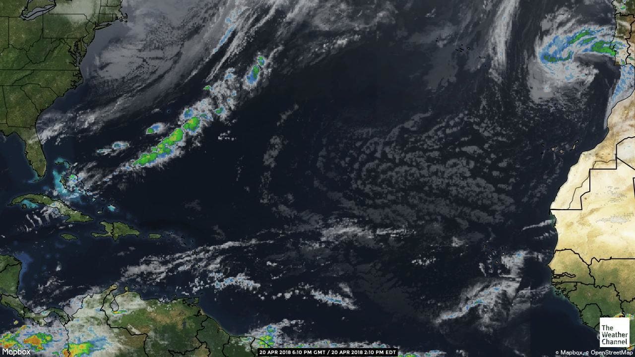
The same frontal system now the rain can be seen laying along the front. The 2nd band passed over us late this morning. Thank you Weather Channel.

Older posts Newer posts