- Captain Albert's Website and Blog -

Ocean Liner History and Stories from the Sea, Past and Present. With an In Depth focus on Holland America Line

Category: excludeRecent (page 62 of 82)

14 July 2015; B.C Inside Passage.

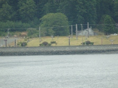
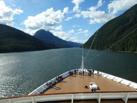
With our sightseeing done and a late Seymour Narrows tide the Zaandam took the wide route through Queen Charlotte Sound. This area is outside the compulsory B.C Pilots coverage and thus we could say goodbye to the Pilots just before 08.00 hrs. at Pine Island. Not that we saw much of Pine Island as once again we had restricted visibility and we were sailing inside a very small world.

The B.C pilots are on board because we sail the Inside Waters of British Colombia. As with the rest of the world, the moment you come within the 3 miles of land, you fall under the jurisdiction of the country which borders at the sea. When you come within 3 miles of the B.C coast with the intention of going inland you need pilots. Understandable as the local government would like to have representative on board to ensure that the ship coming in, knows what it is doing. Secondly, even if it knows what it is doing, it might not have enough knowledge to sail safely through the area.

That is ever so true for the BC Inside Passage. You need a lot of local knowledge to sail safely through it. I think now with 35 years on the coast and with over 300 cruises here under my belt, I would be able to sail the area safely. But you never know what that other ship would do, if that was allowed to operate without a pilot as well. Thus we have pilots on board on every ship over 300 tons and the world is much the better for it.

BC pilots coverage area. according to the chart from their website. With thanks for using it.

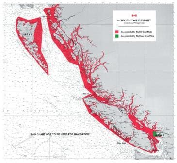
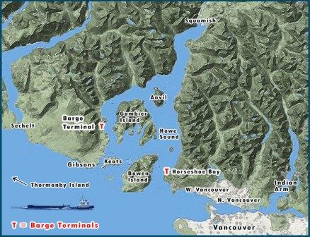
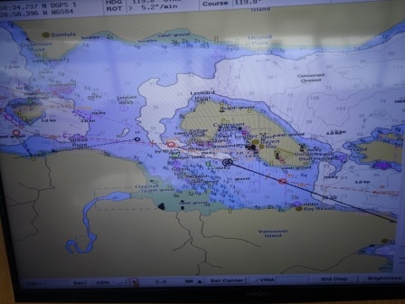
BC pilots coverage area. According to the chart from their website. With thanks for using it. Everything in red is covered by Pilot requirements and services.

All these pilots have a lot of local knowledge and most of them have started out as deck hands on the tugboats. And if there is a way to learn how to deal with currents and “going around the corner” in the Inside Passage, it is with getting your experience on a tugboat.  Some tugs only make 5 or 6 knots of speed and with 6 knots against you, the phrase “making head way” suddenly gets a whole new dimension. Same for going around the corner; making six knots with a big barge behind you and then having four knots current on the side. That can also result in a very peculiar way of travelling. I have seen barges almost over taking the tugboat and I have tug and tows giving up on going through Seymour Narrows as they missed the window and sought shelter out of the current to wait for the next slack tide.

To pick up the pilots there are basically three stations. One is Triple Island on the border between Canada and the USA. Here ships collect a pilot for going to Prince Rupert or through the Inside Passage to other destinations including Vancouver.  Then there is Pine Island which mainly serves the cruise ships and is there to give the option for the ships to stay in the schedule to and from Vancouver, if Seymour Narrows slack tide is at an odd time. Odd meaning, it is not in synch with the cruise schedule of the ship.  Location number 3 is Victoria, which serves all the ships coming up from the Pudget Sound and from Strait Juan de Fuca.

Because of our longer transits we have two pilots on board, who alternate watches. Those watches are nothing compared to the regular watches the navigators stand. The pilots split the time up evenly between them and in such a way that they have the best rest hours possible. Only on transits shorter than 8 hours, we can do it with one pilot. That works very well from Victoria to Vancouver and vice versa. The distance is about 90 miles and including arrival and departure you can do that in about 6 hours.

As a result of Pine Island pilot station the Zaandam sailed without pilots for the remainder of the day. Queen Charlotte Sound is of course Canadian Waters but it is so wide, that the legislator decided that ships can sail here without a pilot.

The next pilot we will get is the Alaska pilot who will board tomorrow morning around 05.15 Alaskan Time. We will follow the Ruby Princess and the Golden Princess in, which are docking at berth 4 and 3. Those docks are further up the harbor in Ketchikan and to avoid everybody having to overtake each other, the whole parade sequence is already arranged before the ships arrive at the pilot station.

Weather for tomorrow: regular Ketchikan weather………………rain.


12 & 13 July, 2015; Vancouver and going north again.

Today a combined blog as time is flying by with all sorts of items happening. Inspections, trainings and paperwork. One of the things I also do is maintaining a port database of all the ports I have visited in the world; something which started around the year 2000, when digital camera’s came into full use. My first one looked like a Thompson Machine Gun as it recorded directly onto a small CD disk. The ultimate in Digital cameras at the time until they invented the Flash drives.  Now of course the cameras are small enough to fit in any Ladies purse and the simple ones are so cheap you get keep them with a box of cornflakes, so to speak.

Since 2000, my database has been steadily growing and now with going around all the ships, I can pull off the computers whatever the ships have collected themselves during their voyages.  My total “harvest” now stands at about 627 ports of which I have roughly visited about 350 myself.  All this material will eventually become part of a Holland America Line database but it takes time to enter all those 1000’s of photos in the system. That will take place this coming winter. We have a 2nd Officer Lady at home who recently had a baby and instead of letting her go, the company has given her the option to work from home, so she can combine motherhood with still working for her employer. Holland America is really good in trying to set up these sorts of arrangements which work in favor for both sides. In this case we do not lose the knowledge of a good officer and the officer does not lose the job because of family circumstances. As she lives in England I will deliver my database in September and that should keep her in business for most of the winter. Today I merged what the Zaandam had to offer and tomorrow I will upload it all to the ships Main Frame.

My errand yesterday for buying an overhead projector did not work out as planned. All the shops in Vancouver down town had them but not the ceiling mounted version. Ordering on line is not ideal with me travelling from ship to ship so I had to leave it at that.  Back on board I thought, well if the thing does not work anyway, I might as well have a look inside. Navigation Officers are supposed to be experts in everything so why not in projectors.  So I took the thing apart, gave it a good shake, applied a vacuum cleaner to get the dust  out; tightened up the lamp and voila it worked again. It made the Bo ‘sun and sailors happy campers as they can do training by power point again (and show movies in the evening…………). They will need a new one eventually but for the time being they are back in business.

The captain had to make a decision today about when to sail for the tide. Seymour Narrows slack tide was at 21.55 hrs. in the evening, with only a small window to go through on either side of the tidal change; and with slowing down, expected traffic  etc.  it would be very tight to make. Going for that early tide gives more time for sightseeing (as we did last cruise northbound) but if you miss it………………. then you went fast for nothing and have to hang around for at least 5 hours until the next window opens. In the end the decision was to go for the later tide, just after 02.30 on Monday Morning, and not to do any sightseeing after the Narrows.  But it did give time to go sightseeing before Seymour Narrows and so the good ship Zaandam sailed into Howe Sound just outside the Lions Gate Bridge.

Howe Sound. I googled this map and I think it belongs to a tug & barge company. Thank you for letting me use it.

Howe Sound. I googled this map and I think it belongs to a tug & barge company. Thank you for letting me use it.

All on board had a good look to see how the rich people from Vancouver lived. Being close to the city, having an awesome view over the Sound ( It is basically a Fjord which runs all the way up to Squamish) and it is easy to see that Real Estate goes for premium prices here. (2400 sq. ft. with a view is available for just under $ 1 million) So we looked at the good people on their balcony’s and decks and they looked at us. We do not go all the way up Howe Sound but make a turn around Bowen Island which takes about 3 hours to accomplish and then we are out again before the sun sets ………. And the show on board starts.

It started out with a gloomy day but in the afternoon the clouds lifted and we had a spectacular sightseeing event. However sunshine means……………. Restricted Visibility and I think we will hear the ships whistle sometime in the morning.


11 July 2015; British Columbia, Inside Passage.

It was a bit of a grey and dull day today while we sailed through Queen Charlotte Sound. But if we had to have a grey and dull day during this cruise then today was the best day; as most guests were focused on what happened inside the ship.  By the early afternoon when we re-entered the Inside Passage again, it had cleared considerably and we could do the sightseeing as had been planned yesterday.

With slack tide at Seymour Narrows being around 10 pm. there was sufficient time in the schedule to sail with a sedate speed of about 15 knots through the various waters of the Inside Passage and make a little detour. Average speed needed was about 12 knots but we were unlucky with having the Tide/current against us all the way until slack tide Seymour Narrows. So we went for 15 knots.  Not good for the fuel consumption and thus we did not have a very happy chief engineer.

By 14.00 hrs. we passed Pine Island which marked the beginning of our bit of the Inside Passage and then the ship sailed for Alert Bay.  Coming from the West you go south of Malcolm Island, sail north of Haddington Island and then south of Cormorant Island on which South side Alert Bay is located. I like this route as everywhere there is something to see. And as I had not been here for about 3 years, I made sure that I was on the bridge.

Passing south of Sointula and north of Haddington Island.

Passing south of Sointula and north of Haddington Island.

When you approach Haddington Island in the middle of Comorant Channel, you see three things. Sointula to the North, Haddington Island straight ahead, and Fort McNeal on Vancouver Island to the South. (Thus on the sb side as we were coming from the West) Sointula is a settlement which was founded by Finnish immigrants in the 19th. Century. They could continue the lifestyle they were used to, being logging and fishing. Sadly both the logging and the fishing are both in sharp decline and that means that the village is also in the decline. With no work at hand, the young people have to leave and that severely threatens the future of the town.  I went ashore there once, in 1985, for a medivac. It had been arranged that an ambulance would come over with the ferry to Sointula and I would meet the ferry there with the tender and the patient. I had never heard about Sointula being Finnish so I was expecting more people from Indian decent than anything else. But as not much happens in Sointula, my tender arrival was the highlight of the day, and so was I. With blue eyes and blond hair, I fitted right in, and was very quickly surrounded by a gaggle of tall blond haired, blue eyed young ladies. A ships officer in uniform was a nice change to seeing lumberjacks all the time. I was in no hurry at all to leave again. Fortunately for the patient the ambulance was on time, unfortunately for me the ambulance was not delayed.

The town of Sointula. to the left the local ferry which connects Malcolm Island with Vancouver Island.

The town of Sointula. to the left the local ferry which connects Malcolm Island with Vancouver Island.

On the other side there is Fort McNeal which is expanding. More and more people retire there, or stay there after retirement and some really nice and expensive Real Estate is now on show. Once passed, you get Haddington Island on the sb. Side. There used to be a quarry on the island which produced the stones for B.C. Provincial House. Once passed Haddington, it is time to look to the left and then Alert Bay comes in view.

DSC01879

Home to the tallest totem pole in the world, although they had removed a cross bit from the top, since last time. What also had been removed since last time was the mission school.  Although it presented a rather dark chapter in the local history, the last thing I had heard was that it would be changed into a Museum for the local history. But it was gone. Maybe it had become too derelict.

Totempole Park in the centre of Alert Bay.

Totempole Park in the centre of Alert Bay.

The totem poles in down town were still there but they are getting greyer by the year and I could not see a new one having been erected. This either means no Indian Chief has died recently or they have given up the practice. I hope the former. Our friend with the trumpet was not there either; according to the pilot he had not been sighted in the last two years.  Maybe he finally found fame and is now playing somewhere more permanent.

Passing Alert Bay as seen on the Electronic Chart.

Passing Alert Bay as seen on the Electronic Chart.

By 1700 hrs. everything was over and the ship sailed into Johnstone Strait. There was still a chance to see Orca’s but July is a little bit early in the season so I was not expecting much. Time to go back to the computer and hammer out another inspection report for my Colleague Capt. P.J van Maurik. He will now spend most of the evening on the bridge for passing Seymour Narrows. Tomorrow morning it will be 06.15 under the bridge and then line up for a 07.00 hrs. docking.

Weather for Vancouver; Overcast with a chance of showers. Perfect for me, going for my next chance to get a new overhead projector for the Bo’sun store. I will have some walking to do and then you do not want the sun burning down between the buildings.


09 July 2015; Juneau, Alaska.

Today was a real cruise port day in Juneau. All but one of the docks was full and occupied with 3 large cruise ships and a small one, the Safari Explorer. A most unusual name for a ship in Alaska as you relate the word Safari more with African Adventures than with looking at bald eagles in Alaska.  But it does make adventure cruises catering for 36 guests in a ship / yacht of 145 feet in length as a Safari qualifies as an adventure I suppose. This little ship was originally constructed as a research vessel and then in 2008 revamped into a luxury explorer. We see quite of few of them pottering around the highways and the bye ways of Alaska.  They run totally different programs than we do. So it was not amazing that she left while we had just arrived. The guests on board such a small explorer are less into shopping and more into getting very close to nature. As close as possible and I was not amazed to a whole pile of canoe’s or kayaks carefully stored on her aft deck. Going to places in Alaska were the big boys cannot get to.

There were three big boys in port today:  The Celebrity Infinity, The Norwegian Sun and the Zaandam.  We were docked at the Alaska Steam dock which is as close as you can get to down town. Behind us at the Cruise Terminal, was the Infinity, not a bad place either and then far away at the A.J Dock was the Norwegian Sun. The Franklin dock, normally occupied by a Princess ship was empty. Through the years a sort of pecking order has established itself, meaning that the most senior cruise company, that is us, gets the best dock as long as the ships are fitting in.

An overview of the Juneau docks. this photo is courtesy of a local Juneau sightseeing company called Harv and Marvs.

An overview of the Juneau docks. this photo is courtesy of a local Juneau sightseeing company called Harv and Marvs.

Every dock has its advantages and disadvantages. Alaska Steam, named after the Alaska Steam ship company who maintained a passenger service to Alaska until 1964, is the closest to town. The only down part of it is that with the tides the gangway has to be shifted on a regular basis, causing a disruption of about 10 minutes for the guests.  The Cruise Terminal has a gangway ramp which goes up and down with tides. Although this is a new ramp, the system is left over from the days that this dock was the ferry dock for the Alaska Ferry System. Long time ago they moved to Auke Bay and then the cruise ships came in. The gangway is always at the right level and there is no delay to the guests. It is only an additional ships length to down town and thus not too bad.

With the expansion of cruise business and the increase of the ships, a new dock was built in line with the Cruise Terminal but further down at the south end of Franklin Street, the road which runs all the way along the water of the harbor. To keep things simple they named this the Franklin Dock.  It is the home base for the Princess ships.  A very nice dock but it is a long walk into town for most of the guests.

The finally there is the A.J. dock. Advantages it is a partly floating dock so also here the gangways go up and down with the tide. It is located at the edge of the old rock dump, where the gold mine of Juneau dumped all its spoils.  It is a long way out and thus a shuttle bus is running for those who cannot make the trek to town by foot. It is the least beloved of all docks by the Captains as you have to dock broadside on the prevailing winds and current. Doable during the nice summer days, very challenging during “off days”.  The A.J dock got its name from the mining company.  This dock is used for overflow and for the ship companies who are recent arrivals to Alaska such as NCL and Disney.

Then there is the dock near the USCG station and that one used for all the small ships such as the Safari Explorer.

I had a mission today, which failed miserably. The overhead projector in the bo’sun store had given up the ghost and I thought I would just buy a new one. But in Alaska the options are limited and anything not being a run of the mill item has to come in from the lower 48. But Office Max had projectors in store and thus I went to have a look. With the local bus system, which makes a complete loop through the whole of Greater Juneau every hour.   For 2 dollars you get a great ride and see Juneau from the side of the locals.

Unfortunately, Office Max was confused about a regular projector and an overhead mounted one, and my journey was for naught. Still I enjoyed the bus ride. Next gamble is Vancouver but that is on a Sunday so maybe not so easy either but we will see.

Tomorrow we are in Ketchikan and we are expecting overcast weather again. And anything is good and great as long as it does not rain, which it does for most of the year.


08 July 2015; Haines, Alaska.

Yesterday I made a remark in my blog that might need a little bit more clarification. I wrote “We were in Seward on the 5th. and that meant that the day before it was the 4th. of July, which is also in Alaska the National Holiday.” That would make sense as Alaska is part of the USA. So why the remark? Basically to my utter amazement there are quite a few people on board who do not seem to grasp that. As I am now seeing a lot more of what goes on in the ship, instead of mostly living on the bridge, there are a considerable number of guests who see Alaska as something foreign or at least not directly being part of the USA.  Americans and non-Americans alike. I had heard about questions before at the Front Desk if they could pay with US dollars in Alaska or with an American credit card but I had  never given it much thought.

Until during the last northbound cruise I picked up, here and there, a few snippets of conversation which brought the message home.  The three things I heard this time:  They speak Eskimo in Alaska, Lumberjacks have the right of way (Do not ask me where that one came from) and Alaskans do not like to fly the American flag; they have this “blue thing”.

Also Haines where we were today; has come in for some of those remarks in the past. The one I liked the best, this was some years ago, was the exclamation of a lady going off the Gangway: “look Harry, see those nice white houses on the hill? Answer: “keep going dear, they build foreign over here.”

Well they do not build “foreign” in Haines but the scenery looks different compared to the other ports we visit and that gives it its charm. The sky line of Haines is dominated by (ex) Army buildings, and thus a lot of the houses look a bit different than what most guests are used to seeing at home.

According to Wikipedia, The army built Fort William H. Seward south of Haines in 1904. Later it became Chilkoot barracks named after a town nearby, which later merged into Haines. Until the 2nd world war it was the only Army post in the Alaska. The fort was deactivated in 1946 but some gun emplacements are still there and of course the housing of the Army Officers, which can be seen dotted against the sky line of Haines.  So the latter makes the town look so different.  The fort itself was restored in 1972 and is now a National Landmark.

Haines as seen from lifeboat nbr. 2 during low tide. the large white building on the right was once part of the army barracks.

Haines as seen from lifeboat nbr. 2 during low tide. The large white building on the right was once part of the army barracks.

Thus Haines might be missing the shopping of Skagway and the train up the mountain but there is enough to do to keep one happily occupied for the day.  What some guests found very interesting was the General Store in Haines. With the shopping Malls, Home Depot and other large chains, General Stores have disappeared from many places in the USA but in smaller Alaskan towns, especially those which have limited connectivity with the outside world, they are still there. For one Family today it was a nostalgic tour to go there, as “Grand pa’s father had one in the 1930’s”.

Today it was a real Alaska day. Very little rain but overcast with low hanging clouds.  Tomorrow we are in Juneau and the weather is supposed to be the same. Another Misty Mountain day as Tolkien would say.

07 July 2015; Glacier Bay, Alaska.

The weather in Seward and yesterday in the Gulf was really too nice and thus we had limited visibility from late yesterday afternoon until we entered Glacier Bay this morning. That is the price you pay for sunshine in Alaska.  Still restricted visibility only bothers the Captain and the navigators, the guests do not suffer much apart from the fact that there is no view outside the ship.

It is still much better than having a bumpy ride in the Gulf of Alaska. A good example was autumn 2012.  Details can be found in the Blog archives. I was joining the ship in Seward and my colleague Capt. Consen was going home from there. There was a very nasty storm brewing under the Aleutians and all the worry was about getting to Seward on time for the overland tours and those who were going home. In the end the Captain had to make a very difficult decision and that was cancelling Glacier Bay. Highlight of the cruise and the ship was full of unhappy campers. In the end everybody understood the issue, they were still not happy, when they saw the bad weather approaching on CNN. The Statendam slipped in, just in time, into Resurrection Bay before all hell broke loose outside.

The ship came early running ahead of the storm and that gave an overnight in Seward. This place is not exactly known for its abundant night life but everybody could leave on schedule when the time came. I joined that day, had one look at the weather, and decided not to sail as the swell at the entrance to the Bay was still about 25 feet. Luckily for me it was easier to do this as I had spare time on my sleeve to get to Glacier Bay. So I sailed the next morning when the swells had subsided to 15 feet and then with wind and waves in the back surfed to Glacier Bay without a worry in the world. As it was still windy there was no restricted visibility either so it was the best of both worlds.

We were in Seward on the 5th. and that meant that the day before it was the 4th. of July, which is also in Alaska a National Holiday. They have the usual parade and everything else an American town does but they also have the climbing & descending of Mount Marathon just outside Seward.  I never realized it but there is a sort of sub culture among  mountaineers who specialize in running up and down a mountain as fast as they can. In the beginning it was just a few locals who did this here in Seward but slowly and steadily it has become an international scene.

I pulled photo off the Internet (thank you whoever posted it) as it shows quite nicely the hair raising run which it is,

I pulled this photo off the Internet (thank you to who ever posted it) as it shows quite nicely the hair raising run which it is,

The fastest runner/climber/glider or whatever you want to call them was this year a man from Spain who participates worldwide. He managed 41 minutes (according to our local pilot; I have not verified this) for the whole parkour. I have walked near the start of the route and in my opinion it is sheer madness but there are people who like to take things to the extreme. Mount Marathon is such as extreme and on occasion runners have been crashing down in quite a spectacular way. This year all went well and there were no accidents. (Again I rely solely on information provided by the local pilot)

Glacier Bay is less extreme and we had a quiet and overcast day in the bay. During the Southbound cruise we have a late morning arrival so we can time our sail around in the Bay with another ship which arrives early. Thus the Rangers joined at 10 am and they left again just after 19.30 hrs. They really do not mind leaving at that time as it means they can have an extensive dinner on board. Always better than the local grub at the Ranger Station.

Tomorrow we are in Haines. Holland America is still the only cruise company who consistently calls at Haines while other company’s limit themselves to a few calls. Sometimes only if they have been blown out of Skagway.  I like Haines as it is less commercialized than Skagway.  The Council of Haines wants more ships of course as it helps the economy and has slashed the docking fees by 50%. I believe it was $ 3000 for a call and it is now down to half.  If that helps remains to be seen as such a low docking fee does not make much impact on a ships turnover of more than a million a cruise.

Maybe free beer, from the local brewery would do the trick, as it is really good stuff. Maybe free tickets to the hammer museum as well; as that is truly unique.  Whatever the case, the Haines people have arranged for dry weather and that is all that we want. So Holland America will be there every week of the summer with a ship.

06 July 2015; To Seward and back, Alaska.

The cruise of the Zaandam terminates in Seward at least for those who go home or go overland. I found out during the changeover in Seward that we had about 200 on board who are making the cruise back down to Vancouver as well. That cruise is nearly the same except for calling at Haines instead of Skagway.  Holland America has been going to Seward since the early 1990’s when the Rotterdam V initiated the service. Our company opted for Seward because Whittier, just around the corner, was much more of a blowhole than Seward. It has not been unknown for the ships there to be delayed in arrival because the weather was just too inclement. Courtesy of the fact that the Whittier dock is much more exposed.

Seward is located deep in a fjord and when it blows, then it is mostly north to south, that is in line with the dock, and that makes the chance of docking for 99% certain. I believe in all the years it has only been once that a HAL ship could not dock and that was with the old Rotterdam.  Being a steam ship she was still to a certain extent relying on tugboats and during that one call, the wind was just under the wrong angle, and just too strong for tug and ship together.  Luckily in Seward there is the option to drop anchor just off the dock and that is what we did. Then we just tendered everybody ashore.  Not an easy task in a turn over port, getting the 1000 guests ashore was just regular work but bringing approx. 3000 pieces of luggage ashore with the lifeboats was another thing. (And then of course the same amount back on board again)

We managed the whole operation by having 4 big lifeboats in the water and towing them 2 by 2 with the motor lifeboats 1 &2 ashore. The good old Rotterdam still had rowing lifeboats by means of a Fleming gear system. Which meant that they had to be towed for this short of operation. Ashore we had devised a clever system with a cage attached to a fork lift to overcome the tidal problem in Seward. The tide is on average 10 feet and with high water you might be able to hand a suitcase ashore but at low water that option does not work.  I remember the longshoremen were not too happy about the sudden change in procedures. Going from a cosy conveyor belt operation to lift and stretch with heavy suitcases. But contract is contract so they moaned and groaned as only longshoremen can. I somehow have the suspicion that there are special Moan, Groan and Curse classes given at the Longshoremen Academy, and it sounded as if they were sitting for their final exam. I think it was blowing wind force 8 or 9 for most of the day but as we were anchored so close to the shore, the wind could not whip up any waves and we could run a perfectly nice and smooth operation.

Thus while Princess favors Whittier, Holland America has happily stayed in Seward. Then Princess showed up for a few seasons with a Saturday ship and then disappeared again. I have never found out if they did not like Seward or that the Saturday routine did not work.  Then for a number of years Celebrity and RCI were there as well, calling on Sundays the same as we did and still do. But now they are also gone and we have the dock to ourselves again.

blog Seward DockThere is more than one dock here. To the right of the Railroad dock, where we dock, is a small dock, used by barges which bring in the supplies and to the left is the Coal dock where every so often a Japanese Bulk carrier arrives to fill up with coal coming from the interior.  Then there is a large Marina near the town of Seward, wildly popular in the summer when the fishing season is open.  Also for them there is the advantage of Resurrection Bay being nice and sheltered.

Most of the summer there is very little wind but that changes quickly near the end of August. For those who watched “The deadliest catch” know that can be very spooky here. The headache for any HAL captain is that we have to go to Seward whatever it takes, because it is a change over port. If we do not arrive, or arrive late then we endanger the operation of  30 or 40 overland tours by bus, train or other means; and we endanger those who have to fly home to go back to work again. Deviating to Anchorage, Kodiak, Homer or Whittier has no use as those places have the same weather, most of the time even worse than sheltered Seward.

So we have to be clever then about what to do. More about that tomorrow. In the mean time we have made our change over call in Seward and are now heading back to Glacier Bay sailing over a flat and very smooth Gulf of Alaska.


03 July 2015; Glacier Bay, Alaska.

It is not always easy to get on line if the ship sails between mountain ranges. Yesterday we were in Skagway and we docked at the Railroad Dock. Which is a great dock, preferred by all Captains, as it is nicely in the shelter from the prevailing winds. Problem is those mountains also “shelter” the ship from any Satellite connection a lot of times.

For the coming days we will not have this issue as we will be more in open waters. Although Glacier Bay in an inside fjord, the mountain ranges slope towards the water which means there is nearly always a satellite in a direct sight line to catch the electronic traffic going in and out of the ship.  As we have no option to hook up to a regular telephone line we have to rely on satellites, which is not always the cheapest or the most satisfactory connection.  But in order to get a connection at all there is a lot of expensive equipment involved.

Not everybody realizes that communication with a ship is not as simple as with a land line or with a cell phone which hooks up with every cell phone mast in the area. Quite often we do not have a cell phone mast nearby; most of the time we are our own cellphone mast. That means that an electronic signal sent from a computer on board, first has to go up 30 miles in the sky to catch a satellite. Then that satellite has to send the signal 30 miles down again to the receiving station. Then the signal is forwarded to the company server (More or less in the same way as at home where a signal goes from your computer to a modem or router and back again). Then the signal goes to the server where the webpage is kept that you want to access. A response has to travel the same way back. So if you are surfing on line or connecting to a specific website, there is this constant Ping-Pong to and fro via this whole extended route. That takes time and if there is a mountain partly in the way it goes even slower. It makes our on board internet seem slow at times and there is nothing we can do about it; even if each ship had a satellite which would hang directly over the ship all the time and followed it foot by foot. The distances to travel remains the same.

I do not think that many people were on the computer today as it was a glorious day in Glacier Bay. It was rainy at the lower bay where we picked up the National Park Rangers but as soon as we travelled up the Bay the clouds broke and it was nice and sunny. To my amazement there was very little ice in front of the Glaciers. The Glaciers had not been very active. The down side of this is that there was very little to no calving; the plus side was that the Captain could bring the ship very close everywhere as there were no ice cubes to hamper a safe progress.

With no ice in the way the can sail close enough for these sort of details. (Photo Courtesy HAL Library)

With no ice in the way you can sail close enough for these sort of details. (Photo Courtesy HAL Library) Nearly every Glacier has a river under it. A tunnel which drains off the melting water from the underside of the Glacier. On low tide this river is clearly visible.

We stayed in the Bay from 07.00 hrs. until 17.00 hrs.  The whole time the Rangers are on board.  Some of them live all year around at the Ranger Station at Bartlett Cove but quite a few of them come only for the summer season to ride the cruise ships and to provide narrations and a scientific context to our day of sightseeing. Some then return to University but others divide time between two National Parks. In the not so distant past we had one ranger who we called “Mr. Whale” among ourselves. Not that he looked like one but because he seemed to follow the yearly migratory route of the whales. In the winter he was in Hawaii and in the summer he was in Alaska. His dream was  one day to get funding for a boat to follow the whales on their complete year around cycle. When we asked him if his girlfriend would not get lonely then, he looked quite perplexed; it was a given for him that she shared the same passion for the whales and would be on the same boat.

Tomorrow we will spend the day crossing the Gulf of Alaska. The weather looks quite good and thus our guests will have a nice day to finish their cruise. Most of them are going home as far as I understand but a fair few are travelling inland to see Denali park.

29 June 2015; Inside Passage, BC Canada.

With full speed the ship made it nicely on time to the Seymour Narrows and just past 10 pm. she went through. I was not on the bridge but I could feel it in the cabin; but only if you are attuned to it. Even with slack tide in the Narrows, it is not really slack tide. There are always eddies and side currents which are caused by the flood stopping and the Ebb starting. Slack tide is just the moment where one flow is losing it from the other. So when the ship goes through, changing course from approx. 325o to 287o and then to 006o, the eddies around the ship will nudge it one way or the other and will try to push the ship off course. The Quartermaster behind the wheel reacts instantly to such an off course movement and as there is no room for error here, the “bringing-back-to-course” is much more abrupt than normal.  It causes a different movement than one is used to and that is what you feel.

Going through the Seymour Narrows on the early tide means that you have a lot of spare speed in hand for the remainder of the schedule. Ketchikan pilot is always around 04.00 – 04.30 Alaskan Time and as that does not change whatever tide you have to take, it means time and speed in hand. Holland America expects their captains to try and bring as much enjoyment to a cruise as possible and if that can be achieved with some extra, but safe sightseeing then that is what normally happens.

What we do and what can be done depends on a lot of factors. First of all, how much time do we have in hand? Secondly can we go safely where we want to go (if a scenic area is full of fishermen casting nets in the fairway then you do not go there). Thirdly what is the weather going to be like? Fourthly does it not conflict with the on board program and if that all is ok, then there is the next step: consult the pilots. The pilots are apart from the local experts, also representatives of the state and that means that their take on a situation is vital. If there are no issues, then they will be the first to say yes as they are also there to support the Cruise Industry but if they see issues then the captain will listen carefully and decide accordingly.

There are various scenic routes one can take that goes off the beaten track which we normally have to follow if we are on a tight schedule. But this time we were so early that the Captain decided to go through Grenville Channel.  With a regular speed of 10 knots to make Ketchikan on time, it meant that we would be right in the middle around 5 pm. Perfect for cocktail time and Guests who were going to Early dinner could still see it first from the outside decks and catch the rest from the windows in the Dining room.

Approaching the narrowest part of Grenville Channel

Approaching the narrowest part of Grenville Channel

It was a nice sunny day today and by the time we were inside Grenville, the sun was just setting behind the mountains and casting a golden glow over the mountain tops. Very nice indeed. We were not the only one, as ahead of us a Bulk carrier went the same way. Normally we race past such ships but as we were really “cruising” today at our leisure we followed her at about 2 miles distance. We even saw a few whales lazily swimming by and disappearing with a flip of the tail, once they heard our engines. We also saw Red Tide and although it is dangerous for humans, it does not seem to affect the whales as they ploughed right through it.

The shore is enver far away in Grenville.

The shore is never far away in Grenville.

My regular work has started to today, first with enlightening the officers on board in how to conduct a safe Medical Evacuation by Helicopter and then I started my walkabouts in the ship.  Each HAL ship has several audits a year: From HAL itself, from Carnival Corp, from Lloyds, from USCG, from Flag State etc. etc. and the ships want to pass in the best way possible. We now have to comply with so many new rules that there is always the danger that some small thing is overlooked. A matter of not seeing the trees for the forest any more.

So if I can cast a fresh eye on the ships proceedings then that will help greatly. So in the coming 14 days, I will walk the ship, deck by deck, locker by locker and staircase by staircase to see if all is in good shape.

Tomorrow we are in Ketchikan. Rainy Capital of the World. It is supposed to be dry; and Ketchikan dry IS dry even if there is an occasional drizzle.  Drizzle does NOT qualify as rain in Ketchikan.  Temperatures are supposed to be in the low to mid-sixties and that is good as it keeps those Very Low Hanging Clouds away.

28 June 2015; Vancouver, Canada.

Today I boarded the Zaandam in Vancouver which was parked at Canada Place on the West Side at Berth 5. There was one other cruise ship in, the Infinity from Celebrity cruises which is a good deal bigger so she was docked at Berth 1 and 2 on the East Side. Berth 1and 2 are in line, which makes it possible to dock 2 smaller ships there or one big one. The West berth is angled between 4 and 5 and that means that an R class of Holland America is about the biggest cruise ship that can dock there. With the average size cruise ships of nowadays it means that you can have a maximum of three cruise ships alongside Canada Place, if one is a biggie. If there are more in port, then those ships go to Ballantyne a bit further up the river. Because there are during the height of the season always more cruise ships in port, Princess cruises has made Ballantyne its regular dock. The last time I docked there was before Canada Place was opened in 1986 and it was not a bad place if you want to go to China Town. Canada Place is right on top of regular down town and that makes China Town a long walk. Why do I mention this because Chinatown is a big focus point for our Asian crew.  Although they can get everything they like on board, everybody has their own taste in noodles and other snacks; and full boxes are being brought on board. The company allows this with the stipulation that all those snacks will be consumed in the crew mess room and not in the cabin.

blog 28 juneThe Zaandam is making a seven day cruise up to Seward and then seven days down again. You can combine this and make it a 14 day complete round trip which some guests indeed do. Most though have a seven day trip and then either go home or disappear into the interior. If you go for the latter option then there are multiple choices and I believe the longest one offered is over 30 days and goes up as far as the Arctic Coast on the North side of Alaska. Then there is the option to leave or join at Skagway which is yet part of another overland tour. More about that once we get to Skagway.

The Zaandam was parked nose out and that is not completely normal.The manoeuvre  which is the easiest is to go nose in so you can see the ship “diving” in the narrow part of the dock, as across from Berth 5 is a building with restaurants and bars and it does not leave much room. Then on departure you simply go astern and once clear of the dock you have all the space in the world to swing around.  It makes arrival shorter and departure longer. Docking nose out results in arrival taking longer but departure is a very short affair: Let go ropes and race away.

Today the ship was docked nose out for two reasons; first it is the only way to get two gangways into the ship, due to the line up of the shore side facilities. We like two gangways as we can get the guests who go directly to the USA off the ship without having to go through Canadian Immigration.  The ship has come directly from Alaska and is still USA cleared. By sealing off a part of the terminal, the pathway is considered to be “CBP approved” and the guests go directly in a Coach which remains closed until it has passed the USA border. It saves everybody, including the CBP itself, a lot of hassle.

Second reason is that the departure only takes 5 minutes instead of 20 minutes. And today the Zaandam was in a hurry. Captain P.J. van Maurik had decided to go for the early tide at Seymour Narrows and with a slack tide around 22.00 hrs. it means you have to be at the entrance of Discovery Pass around 21.15 hrs. and this leaves just under 5 hours to cover 98 miles. Thus “pedal to the metal” all the way. If you can then shave 20 minutes  off your departure time/ manoeuvre, it makes a big difference in the speed to maintain.

Based on that planning the Zaandam took off as a “Jack –out-of-the- box” just before 17.00 hrs. and cranked up to full speed as soon as she cleared the Lions Gate Bridge.  If we clear the Narrows on time, it means we have a lot of spare time to get to Ketchikan and my colleague has already promised he will go sightseeing.

Weather for tomorrow: Partly cloudy with temperatures in the low sixties. As it has been extremely nice weather in the last few days (read much too warm for the Inside Passage) we can expect a bit of Very Low Hanging Clouds during the night and the Navigator will be happy to announce this by sounding the ships whistle. I have a cabin on the lowest guest deck so it will not bother be. I just have to hope I do not have an aspiring Opera Star next door who feels the need to exercise in the Bathroom.


Older posts Newer posts