- Captain Albert's Website and Blog -

Ocean Liner History and Stories from the Sea, Past and Present. With an In Depth focus on Holland America Line

Page 5 of 234

09 March 2020; At Sea.

With the Pacific Ocean behaving in a very “pacific” way, all was well in the world. The ocean surface was flat enough for the guests to pick out all the wild life around the ship and there was quite a lot as we are not too far from the shore today. We are sailing along the coast of Baja de California or the Californian Peninsula which has the large water gap of the Sea of Cortez that separates it from the Mexican Mainland. Plus we are right on the Whale – Highway between this area, Hawaii and Alaska. Whales swim from Hawaii over to the area south of Cabo San Lucas and then eventually go north to the feeding grounds of the Alaskan waters. Because they are congregating here, think in a mindset of several “whale lanes” coming together at a round-a-bout and then all going up the north lane; so this were you have the best sightings until you go to Alaska. Just before noon time today, some humpbacks gave a spectacular show on the port side of the ship, much to the delight of our guests.
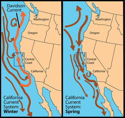
The general status of the current of California and higher up. It brings cold water to the warmer waters south of Cabo San Lucass.

Unfortunately we passed most of this south point area during the night and missed the chance of seeing the waters around Cabo San Lucas. Where apart from the whales, there are also large shoals of Blue Marlin present. Attracted by the meeting of the cold and warmer ocean currents which brings up nutrients from the ocean depths and these nutrients and small animals form the start of the food chain for all sorts of other fish. Same as the whales, also the blue marlin is a seasonal visitor which goes deep ocean for most of the year.  Around this time of the year it is high season around Cabo San Lucas when the Marlins are on the coast. The Operators have a regulated catch and return policy which means the fish stocks are not affected.  Because we passed by at night we did not see all the charter boats going out and coming in, and I am quite happy about that as they do not always follow the rules of the road when regular traffic is coming through.
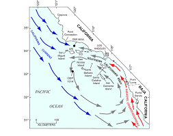
Every captain is a happy camper of he can ride the red current while going up the coast.

Then as soon as you are away from the area, the fishing boats disappear as they are all day boaters, the whale sightings get less as the area where they swim is increasing, and we get the regular ocean traffic back which is on the way from North America to the Panama Canal or vice versa.  Nasty thing for us here is, that most of the time we have the California current against us which brings cold water down from the Gulf of Alaska to the Cabo San Lucas area. Hence the reason why the whales like to travel this route; it is nice and cold.  Thus most of the time we are battling against this current on our way to San Diego. But not always; sometimes the warm counter current (which is caused by the colder water pressure coming down and replacing / pushes away the warmer water) lays a bit further off shore and we just catch it. I have never been able to predict exactly when this happens as no doubt a lot of local circumstances play a role here. Fact is, when the warm water current moves, we get more fog around the area near Cabo.
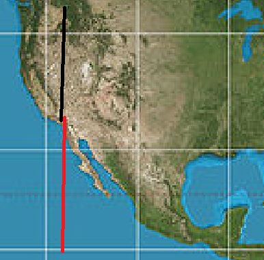
The Mercator Projection which is used by most display charts. USA and Mexico are almost the same.

Tomorrow we have our 2nd sea day and we will still be traveling along the coast of Mexico. Not many people realize how long (North/West) Mexico really is and part of that is due to the false representation on the geography maps that we use. Most of them use a Mercator projection, which is only 100% correct at the point where its projection touches the Earth’s globe. The further away from this point and the larger the distortion. That is why Greenland looks so very big, although being of a reasonable size, it does not go so wide at the top. A better projection is the Peters version, which gives the continents in the right size / context to each other but is distorted in the way it is represented as a flattened globe. The Mercator version distorts the closer you come to the poles and thus Mexico looks a lot smaller than the USA and Canada.  You only really understand this when you are on a ship and you travel for days with the same speed. Then you realizes it takes longer to sail the west coast of Mexico then the west coast of the USA.
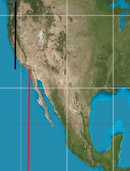
The Peters Projection. The Mexican west coast is now suddenly a lot longer.

Tomorrow we are at sea for our 2nd day. Still along the Mexican coast. Then by 04.00 on the 11th. We enters USA waters and sail for the San Diego Pilot station. Weather has been forecast to still be good and thus we should have a nice final day of the cruise.

Continue reading

08 March 2020; Puerto Vallarta, Mexico.

By 06.30 we entered the Bahia de Banderas at which inner end Puerto Vallarta is located. Being located at the end of the bay is really very nice, as the town thus misses the brunt of the storms that come by during the hurricane season. Only, on the rare occasion that a hurricane turns into the bay, is there a real problem but that is seldom.  In the good old days Puerto Vallarta was a sleepy fishing village frequented by celebrities and made famous by some movies. It is understandable that famous people liked this place as it is not as hot, hot in as further south and if you still find it too hot, you drive up the mountain and it is nice and cool. Continue reading

07 March 2020; Manzanillo, Mexico.

Sailing through a smooth Pacific Ocean, as smooth as I have ever seen it, we approached Manzanillo. It was smooth enough today to see the birds sitting on the water and the turtles peddling by.  Or better said surfing by if they were close to the ship. When I first went to sea I always worried about turtles getting in the propellers until I started watching them to see what happened when they came by. Well, what happens is that they are pushed aside by the bow wave. Turtles, due to their shape, are like corks on the water; corks that can swim. So when they are swimming on a ships course line, they are pushed aside by the pressure wave that is generated by the bow. That bow wave spreads out further and further away from the ship’s hull and the turtles follow, bobbing along on the crest of the wave. By the time they near the stern of the vessel where the propellers are, they are well clear. It might be a bit of a startling experience for Mr. or Mrs. Turtle to be lifted up by this un-expected wave and carried sideways but it does ensure that they do not come to harm.  Bulbous bows were invented to reduce fuel consumption but they also work very well as a gigantic turtle mover. Continue reading

06 March 2020; At Sea.

As mentioned yesterday, we prepared ourselves for the Tehuantepeccer storm that would be blowing this morning. And we prepared with an abundance of caution. And it was a good thing we did so as this was a real nasty one. We always expect 50+ knots of wind and heavy seas (away from the coast) but it blew a lot harder than 60 knots at times. The Captain reported that the highest wind gust observed was 88 knots and periods of a sustained wind of 70 knots between 05.00 in the morning and 07.00 in the morning. That is Hurricane force wind strength. Seas were observed between 12 and 18 feet at times. So much wind blowing caused the ship to list somewhat, although the engineers pumped everything they had from the low side to the high side to minimize the effect. Continue reading

05 March 2020; Puerto Quetzal, Guatemala.

Just after sunrise in very hazy weather and it being nearly wind still as well, did the good ship Rotterdam arrive in Puerto Quetzal. The haziness indicated that it was going to be a very warm day and it was. Only in the late afternoon did it breeze up and thus we did have a bit of cooler sea air circulating over the deck. Since last summer, the local authorities have repaired the cruise terminal and thus could we dock there again. This cruise terminal is made up of fixed bollards and dolphins with a floating pontoon in the middle. And cruise ship captains are very hot on getting this dock as it means that the gangway always has the same angle because the pontoon goes up and down with the dock in the same way as the ship does. This dock has been made for the average cruise ship length and a smaller ship, such as our S class fits perfectly, and the same goes for the Vista Class. The R Class, named after the ms Rotterdam, is an in between length and that means that the Gangway location is not ideal for being landed on the pontoon. Thus we had to relocate the Gangway to the Marshalling area which is normally for luggage, stores and spare parts. But it is amazing what a few sheets and curtains can do to perk up a work area to a 5 star cruise ship lobby.  The Seven Seas Splendor, followed us again and had to dock with the cargo ships. I really am getting the idea that they just follows us, as we seem to know where we are going. See if we can confuse them tomorrow. Continue reading

04 March 2020; Corinto, Nicaragua.

This is one of the trickiest ports to get into. On bad days there is a long and deep swell running over the large area of shallow water outside the entrance which makes it hard to keep the ship steady, even with the stabilizers out. Then there are two turns while sailing in, and at the 2nd one, you can have current from 3 directions at the same time. Something that asks for careful planning. But the company is now coming to this place since 2011 with the cruise ships and thus we have a lot of experience to expect the un-expected. And there is always something.  Also today. With the Corona virus a concern of every health authority, Nicaragua has decided to do a special health check at the sea buoy before sailing in clearance is granted. And thus four doctors boarded the ship and had a discussion with the ship’s Doctor to see what the situation was on board the ms Rotterdam. Well we are completely clean, not even a little bit of Noro virus on board, and after a short time the medical quartet disembarked again and gave permission for the pilot to board. They themselves then continued with a visit on board the Seven Seas Splendor which has been following us since the Panama Canal. They were with us in Puerto Caldera and now also here in Corinto. (Maybe they do not know where they are going, so they are just following us? So I would not be amazed if they pop up as well in Puerto Quetzal) Continue reading

03 March 2020; Puerto Caldera, Costa Rica.

Today we are in a hot and sweltering Costa Rica, mainly because there is hardly any wind, or clouds. As mentioned yesterday, this stop is mainly to offer the guests Eco Tours; same as we have other ports for history (Puerto Quetzal) and other ports again for beach and shopping.  When going here, we have the option to dock at Punta Arenas or at Puerto Caldera. The latter one is officially the cargo port. In the old days it was the only port, but then they built a new pier which leads straight into the town of Punta Arenas. The challenge with the new pier is, it is very exposed to current, wind and swell. So to get the ship alongside you have to arrive at slack tide (change from ebbing to flooding or vice versa) and when the swell is running, then the ship bounces up and down the pier all day, which is not so great for our guests. Continue reading

02 March 2020; North Pacific Ocean.

While exiting the Canal we came as close to the equator as we will get on this cruise but still over 400 Miles North of it. From now on we only be going north until we come to San Diego, the end of this cruise. And we will do that just by following the coast. The Pacific Coast of Middle America and Mexico is fairly straight and by that I mean we do not have to sail around large areas of land that are protruding. The only part that sticks out a little bit is The Californian Peninsula but even that we can do on a straight line. Continue reading

01 March 2020; Panama Canal.

We have a schedule, it starts off with the best intentions and then something un-expected happens.  We did arrive at 05.00 and in the end we approached the First locks, the Gatun locks at 07.00 hrs. but by the time we came out, there was a challenge in the works. Ahead of us was the Wind Star from Wind Star cruises which once in the past belonged to Holland America, until it was decided that sailing motor yachts for an incentive market were not really compatible with cruise ships in the premium markets and thus the company was sold off to an equity fund. (Or some similar sort of investor). But sailing ships have very high masts. And she only fits under the Bridge of the America’s at low tide. (That bridge is at the Pacific side and the Pan American Highway passes over it) Once the convoy starts going, then it cannot stop anymore and for some reason there was no option to put the Wind Star alongside somewhere until the tide was right. So we had to wait from some 30+ minutes. Apart from her, there was one other cruise ship in today, the Seven Seas Splendor, which was “one behind” meaning there was another ship in between, in this case a Car Carrier, or “Auto Boot” in the Dutch Language. Continue reading

29 Feb. 2020; At Sea, Approaching the Panama Canal.

The swell is not as bad as I am normally used to over here. It seems that in the last few days the strength and the angle of the wind has been slightly different than what is normal here, and as a result the swell is lower than normal and thus the ship is not rolling as much as it can do here. That different weather can happen here if there is a cold front going over Florida which did occur on February 27. Then if the tail comes low enough, the prevailing winds change and that results in less swell or a swell from another direction. It does not always happen as it depends on how the tail of such a cold front is moving over Mexico and how far south it extends. This cold front was not very nice for Florida but it works out in our favor here in the South West Caribbean as we do not have a wobbly ship.

Continue reading

« Older posts Newer posts »