With glorious weather we ended our cruise today. Most guests were up and about early and could see a beautiful sailing in, into Boston Harbor. Those who did not were most likely fully focused on their last breakfast on board. This being up and about this early on the last day of the cruise is something we call “channel fever” inside Holland America. It goes back to the Trans-Atlantic days when the day before Rotterdam, while sailing into the English Channel, everybody was up and about early for last minute packing, making final arrangements or just being too nervous to sleep in. Whatever floats their boat, most of the guests were out and about very early. Continue reading
Category: Staff & Crew (page 8 of 10)
I can see why the Scots of Scotland decided to settle down here and named the province Nova Scotia. It has the same weather as in the mother country. As today it was a day as if we were in the Highlands. Foggy, drizzling and with a cold wind blowing. It even came included with a bag pipe player on arrival; dressed in full Scottish gear. So it all felt real Scottish. We had an un-expected quirk in the proceedings as the ship received an email, saying that our berth was suddenly occupied by the Queen Mary 2; which was not supposed to be there at all. But the promise was that she would be gone before we came to the dock. It turned out that she had come in for a medical disembarkation while at the end of a trans-atlantic voyage. We were a bit amazed about that as normally the Canadian Coastguard loves to come out with their boats and do a medical disembark at the pilot station. So either they did not have a boat available or the patient would could not deal with the boat ride back in again. Saving lives always comes first and costs are not taken into consideration; but this must have been an expensive detour. Extra fuel consumption to make and keep the schedule, pilot, linesmen and docking fees and this during the night hours. No wonder the linesmen were in a good mood this morning, they had a good bonus night. We of course worried that the QM2 might not have left on time due to some un-expected complication but she did pull out 0700 and we passed each other just outside the port. Continue reading
Although the ship was in port overnight and the gangway wide open for the whole period, most guests came back on board for a good night’s sleep and then got up again very early for the next set of shore excursions. The Colonnade Restaurant (Comparable to HAL Ships Lido for breakfast and lunch operation although they offer A La Carte as well’) opens at 06.30 on port days but it looked as if they had torn the doors down as half the Restaurant was already full when I arrived at 06.31 hrs. Last night it was very quiet in the ship and I felt really important as I had the whole Club Lounge to myself including the Band. Some guests joined later but when I left the crowdedness of the lounge reduced again by 20%. Still a few people were on board during the day as not everybody participated in tours on both days. For just going ashore, without a cultural goal, Haifa is not as spectacular as due to the curved nature of the port, it lacks a concentrated down town area. So it is not as ideal for a concentrated shopping stroll as might be the case in other ports. Continue reading
Another Sea day, the last one before we reach Aqabah and the wind his changed. Before it was in the back or stern and it increased during the day time which is normal for winds generated by landmasses warming up. That changes about half way up the Red Sea. And we were halfway yesterday afternoon. At about 1600 hrs. we passed Mecca with its port, Jeddah, on our starboard side. We had 50 miles to starboard and 50 miles to port so our course stayed as far as possible from all the land around us. Now we are coming closer to Europe and Asia so other landmasses, read temperatures are starting to play a part in the weather equation. And thus in the early morning hours the wind breezed up and is now against us with a nice wind force 4 to 5 blowing (20 to 25 knots) and the ship is “bumping” into it with 16 knots of speed. This gives a bit of movement as the Seabourn with being smaller does not have all the options of a larger ship, with a bigger bow, to ride over everything. Continue reading
We are now on our way to Al Aqabah which is a five day sea voyage up the Gulf of Aden and then into the Red Sea. Eventually I hope to report if the Red Sea is indeed red or if there is something different going on (Or was going on, when they came up with the name). But that will take a while as of lunch time today it was still 500 miles to the Bab El Mandab rock formation which forms the official entrance to the Red Sea coming from the south. We are sailing at a considerable distance away from the shore line, to stay in international waters but also to stay away from fishing boats and other mayhem which tends to congregate on the edge of the deep water to shallow water. That is where the fish tends to come to the surface and might swim straight into the nets. Continue reading
We are following the recommended deep sea route so we are quite far from the shore. This makes sense anyway as it keeps us clear all sorts of Sunday sailors and fishing boats who are normally hovering on the edge of the shallow and deep water line as that is where the fish tends to come up from the deep. We are in deep water, very deep water. In relative distance the depth of the sea increases quite rapidly from being shallow and below us we have about 4000 feet of water and that is not even the deepest part.
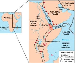
The tectonic plate movement in the area (Thank you wikipedia)
The cause is another continental divide. We are here at the eastern rim of the Arabian Tectonic Plate which is crushed against Europe by the African Plate. I have blogged about this before, explaining the Wegener theory (not a theory since a long time anymore) that the continents are a sort of parts of a large dinner plate (broken in to the continent pieces a long time ago) that mainly drift westwards but not always. Far down at the sea bottom the two plates meet and slowly but steadily the Somalian Plate pushes the African Plate to the North East. So the distance from South America is getting larger by a few centimeters every year. The Arabian plate has nowhere to go but follow and here the mountains are getting higher. (Wait a million years and you can see the difference) This is caused by the west moving Somalian plate which is pushing under the African plate and that gives these very deep canyons under water. And we are sailing right over the top at the moment. Continue reading
Thus we sailed from Dubai Westwards towards Sir Bani Yas Island. This is an island which looks as if it is a sort of knob that has broken off from a protruding piece of land sticking up into the lower part of the open sea. And that sea is in our case the Persian Gulf with Africa to the South and Saudi Arabia to the North. Bani Yas is part of the United Arab Emirates and shelters a number of important refineries. So this morning while the ship approached it was surround by fishing boats but also by tankers, going in, going out, or being at anchor. As mentioned yesterday there are a lot of shallow areas and the port authorities are putting a lot of effort in to ensure that nothing goes wrong with these tankers. A tanker running aground and spilling oil would be a catastrophe that no authority wants to deal with. Thus the routes through the reefs and shallows are dictated by the port authorities and the only thing the captain can do is follow the dotted line and ensure not to deviate from it. Deviation would mean a very hefty fine and some very upset people on the other side of the VHF. Continue reading
When I was on the Zuiderdam I blogged about the ships movement when going from Aruba to Cartagena and from Cartagena to Panama. The strong Trade Wind pushing in the back and the subsequent waves & swell caused a corkscrew motion of the ship. All with the stabilizers doing their best but limited in their success. On this run we are going the other way. So we do not have following seas which catch the square stern and lift it up; now the sea movement hits the pointy bow and lifts it up. The result in a similar movement but at the same time different. Continue reading
Puerta Chiapas can be a problematic port due to the swell that can run straight into the entrance. A swell from the West, North West or South West can cause such a surge in the entrance that a ship cannot safely enter. The swell rolls in and bounces back from the Eastern Sea wall and then sometimes bounces back from the Western sea wall as well. The fact that the entrance is barely 35 to 40 feet deep exacerbates the problem even more as the swell energy cannot be absorbed by deeper levels of water. If the swell is high and a ship would go in, it would be exposed to a rolling motion as if you are being rocked in a cradle on steroids. Continue reading
We are now halfway and have just passed Acapulco. Then this evening we will pass Huatalco followed by the crossing of the Golfo de Tehuantepec. Then by tomorrow morning we will be in Puerto Chiapas. With a wonderful day at sea, low swell, following wind and lots of sunshine, pace on board slowed down considerably and guests were charging their batteries for the two coming ports of Puerto Chiapas in Mexico and Puerto Quetzal in Guatemala. Both ports in the itinerary because of the tours to Maya Ruins, Tropical Forests and old towns. Continue reading
Captain Albert

© 2025 – Captain Albert's Website and Blog –
Theme by Anders Noren — Up ↑