- Captain Albert's Website and Blog -

Ocean Liner History and Stories from the Sea, Past and Present. With an In Depth focus on Holland America Line

Category: Trans-Atlantic (page 3 of 3)

Captain Albert: 04 May 2009, Crossing the Atlantic Ocean

Captain Albert SchoonderbeekCaptain Albert Schoonderbeek

We were blessed with yet another day of good weather. Due to the new wave field coming in from the North the ship was moving a little bit more compared to yesterday but it is still a very smooth crossing. Also the light Northerly Breeze brings cooler air to the ship and thus the temperatures are about a degree less at noon time than they were yesterday. All and all it is fabulous weather for a spring crossing.

Today we also celebrated the middle of our crossing (more or less….. so it fitted in the entertainment schedule) and our cruise director marked the occasion by organizing a North Atlantic swim in the aft pool. This was a well attended affair and enjoyed to general acclaim; especially when the Cruise Director, startled by the ships whistle, fell fully clothed into the pool.

For the navigators a crossing is a peaceful affair with ships being far and wide in between. Yesterday we only sighted one bulk carrier but that ship came fairly close to us. So even on a crossing with hardly any traffic there is no room for complacency as one ship out there is enough to collide with.

One of the chores of the navigator on duty is to send a weather report ashore every six hours. There are now weather satellites that are so sensitive that they can measure everything from a great distance and with the internet the results are instantly accessible. There are weather sites you can log on to and see real time cloud formations moving over the globe. Huge computers are used to refine the prediction models upon which the Meteorologists base their next weather forecast and the predictions get more and more accurate all the time. However as we all know; the weather forecast is not always right and sometimes even completely wrong. It would not be the first time that we have been forecast partly cloudy skies and the next morning you can scoop 6 inches of that “partly cloudy sky” from your front porch.

Thus the meteorologists are very keen to get constant input from local observations. On land this is done by official agencies such as Airports and Coast guards but also by regular people. I know of one gentleman in my home county in England who has been doing this for 40 years without missing a single day. At sea it is done by the ships that participate in the program. This can be done in conjunction with the national weather service, which for the Dutch is the KNMI, or with the American side which is called the VOS project. (Vessel Observation) All Holland America ships are part of the VOS system as we mainly sail off the USA coast with only a few ships away for the summer in Europe.

And so every six hours, the navigator on duty or his assistant fills out a standard number of observations. Wind, waves, height, temperatures, etc.etc. If there is anything special observed, like water spouts etc. that can be added as well. The end report, we call this an OBS (coming from the word observation), is sent by email or satellite radio to a shore station. All the receiving shore stations are linked and the observations from all those ships that participate are shared. The observations are plotted in a chart and also become part of the enormous databank that is being used to create weather models for predicting the weather.
obs-doc-version-300x238
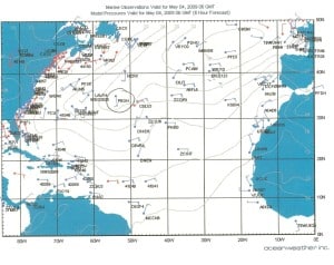
The circled position indicates where the Prinsendam sent in an OBS during May 04, 0600 GMT.

The nice thing is that we can see on the internet each day the result of our own observations, as they are plotted in a chart that is accessible in the public domain. Thus we can use our own observation together with those of all the other ships to get a picture of the actual weather around us. The observation of the Prinsendam is plotted in the chart shown above and we can recognize it as the ships call sign PBGH is printed next to it. As each ship has a unique call sign, it is easy to see how many ships have been sending in their OBS.

(Each country or flag state has an allocated number of call signs for their ships and the Dutch ones all start with a P. That P comes from the word Pays-Bays. Or Low Lands, the name Netherlands in the French language)

Tomorrow we have should have another peaceful day at sea.
Captain Albert: 03 May 2009, Crossing the North Atlantic

Captain Albert SchoonderbeekCaptain Albert Schoonderbeek

This is the 3rd day of our crossing and the weather is holding fine. The sun is shining and with the temperatures in the low seventies it is very pleasant on deck but not too warm. The waves have changed direction again today thus the ship is riding very steady. Tomorrow there is another wave field coming from the north and then the ship will move again a little bit. This is relative as we only talk about waves varying between 2 and 3 feet instead of 4 or 5 feet. It is expected that the weather will remain nice for the foreseeable future. I promised yesterday to tell you something about the time changes on board the ship and why we are doing it on board the Prinsendam during the day time. There are options galore for when to give a time change and there can be heated discussions about which option is the best. Most of the time it all depends on what issue on board is affected the most by the moment of the time change.

Due to the fact that the earth is round and circles around the sun; we have to deal with the phenomena of day and night. And it is day or night at different times in different places, all depending on when the earth turns a part of its globe in the direction of the sun. If the world was flat and did not move than we would have either sun all day or night all day (unless we made the sun move of course) As a result of it all we have different times at different locations in the world. The standard measurement for the world time, at least for us sea farers, is Greenwich Mean Time (GMT), which is English time without the adjustment for winter time. Greenwich has been chosen to be the zero point. From there we count time differences in minus when going west from Greenwich and in plus when going East of Greenwich.

When we left Fort Lauderdale we were on GMT – 4 hours and the Azores with Punta Delgada are on GMT +/- 0 hours. So they are sitting on the Greenwich zero meridian or at least close to it; in the same time zone. Thus to get from -4 to 0 we have put the clocks forward by 4 hours. We could do that in one go. Say at 8 am, we put all the clocks forward by 4 hours, which makes it noon time. Apart from losing a whole morning (no lectures, no bingo, no coffee time and breakfast and lunch would be combined in a brunch) it would play havoc with the sunrise and sunset, because the ships time would jump four hours towards the sun but the sun would still be rising at its own time. Thus it would be dark until quite late in the (ships) morning.

Therefore the routine is to do it in steps. If you would be on a slow ship, taking 8 days for a crossing, you could do 30 minutes each day. On a faster ship you have to do one hour each day to make it a gradual happening. It also makes it easier for your body to accept it. (Airplane flights have a large time change in just a few hours and those result in jet lag)

Hours forward take time away. If we have to do it between ports, then it is done early in the morning, when everybody is asleep, but you will loose an hour of night rest. With an ocean crossing, people come for rest and relaxation and then loosing an hour’s sleep nearly every night is not pleasant. If you do it in the middle of the day, you hardly miss that hour. It is around lunch time anyway. So you still go to lunch around noon time, you finish lunch instead of 12.45 at 13.45 but you still have the whole afternoon ahead of you. Also you are less inclined to go to bed early than otherwise would be the case when it feels like 10 pm. new time already at 9 pm. in the evening.

My experience is that lunch time clock changes have less of an impact on shipboard life than multiple night time changes during a crossing. Thus I do my Voice from the Bridge each day starting at 12.00 hrs and ending it at 13.05 hrs.

Tomorrow is another sea day and then I will explain something about weather monitoring that we do onboard. In the meantime our medivac crew member is still in Hamilton hospital. He is doing better but still needs to undergo a plethora of tests as it is still not certain what his medical problem is.

Captain Albert: 02 May 2009, Crossing the North Atlantic

Captain Albert SchoonderbeekCaptain Albert Schoonderbeek

This was the second full day at sea and again we had glorious weather. A gentle breeze was blowing from the southeast, a low swell was running from the northeast and there were just a few clouds to the North of us. As we were heading into the wind with 20 knots (that is a wind force 5) it was a bit breezy in the bow area but it was perfect at the stern. Everybody was settling down in a nice routine, enjoying the ship and its amenities, and I was hoping for a “boring” day so I could deal with the last of the hand over paperwork. However sailing a cruise ship is never boring, even when you hope for it. Murphy is always around and as we sail with people things will always happen un-expectedly.

So it was no different today and suddenly I had a medivac (shipboard medical evacuation) on my hands. In the course of the afternoon a crewmember had been submitted to the ships hospital and his situation was so serious that the doctor requested to have him disembarked as soon as possible. That is not so easy in the North Atlantic when you are far away from land. You cannot just request a helicopter to coming flying over. If you need a helicopter you will have to be inside its acti-radius and that normally means changing course. This is called “deviating” at sea and that might even mean sailing the opposite way, back to where you came from, until you come to a port or are within helicopter reach. Thus a decision to approve a medivac is sometimes difficult to make as it quite often has a big impact on the cruise schedule. However a captain will always agree with the doctor’s request and arrange a medivac unless it would endanger the ship itself or it occupants. If this danger is not present then the medivac will take place even if it means that one or more future ports of call have to be cancelled because of the delays caused by it. Human life takes precedent over all.

However in this case I was in luck as we were passing by Bermuda in the course of the evening. As explained yesterday I had chosen the Great Circle route to Punta Delgada to save time and fuel and that route was taking the ship just South of Bermuda. So I only had to change course a bit to the North and head for St Georges sea buoy. The local agent was called and he set all things in motion. The pilot boat was arranged to come out and take the patient off. Only thing I had to do was to get as quickly as possible to the sea buoy which was our rendezvous point. With the pedal-to-the-metal we arrived there at 10.30 hrs. in the evening. I had advised the guests early in the evening about what was going to happen as it would have been a bit strange to suddenly see a fully lit up island passing on the portside while you are convinced that you are in the middle of the ocean; miles way from civilization.

Also Bermuda had beautiful weather and by keeping the wind on the beam of the portside of the ship; the sea was as smooth as a mirror on the starboard side, making it perfectly calm for the pilot boat to come alongside and do the transfer of the stretcher. Everything, clearing the ship, the ships doctors discussion with the shore doctor and the transfer was done within 20 minutes and before 23.00 hrs, the Prinsendam was on the way again. I lost in total about 2 hours of steaming time, so 40 miles to make good due to the deviation but with more than 4 days of sailing still to come, I will be able to make that up. We have a bit of Gulf Stream current pushing us in the back and with the very smooth weather that we have, I will be able to compensate for the lost time/mileage very quickly and thus I expect to arrive on time in the Azores.

Now we are all keeping our fingers crossed that everything will go well with our crewmember. We should get an update tomorrow, when the hospital in Bermuda has had time to evaluate the patient.

Tomorrow is again a sea day with expected good weather and we have now started loosing an hour each day due to the time difference between the USA and Europe. We do those time changes at noon time, clocks going forward, and I will explain the why behind that tomorrow.

Captain Albert: 01 May 2009, Crossing the North Atlantic

Captain Albert SchoonderbeekCaptain Albert Schoonderbeek

This morning at 6 am., we left North West Providence Channel in the Bahamian chain of islands and entered the North Atlantic on our way to Punta Delgada in the Azores. We are supposed to arrive there on 7 May, so we have six beautiful sea days ahead of us. The weather is cooperating with partly cloudy skies and a gentle breeze and the North Atlantic is letting its presence known with only a very low swell. It just makes the Prinsendam move a little bit. Just enough to let everybody know that they are on a ship but not so much that it is really noticeable when you go around.

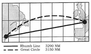
When you cross the ocean you have the option to do that in various ways and that has to do with the fact that the earth is a sphere. Normally it is a given that a straight line gives the shortest distance between two points. However as the earth is curved, it is not the case when the distance becomes longer and longer. Due to the curvature of the earth, a straight line is not the shortest route; it is a curved line or arc that follows the path of the smallest curvature of the earth; we call this a Great Circle line. A straight line is called a Rhumb line. The difference between the two lines is that the Great circle line closely follows the curvature of the globe and is therefore the shorter route, but it takes the ship on a higher latitude. A Rhumb line is longer but stays more to the south.

As a captain I have the option to choose which route I will take. The shorter Great Circle, which will save time and fuel or the Rhumb line, which is longer and costs more time and fuel, but as it stays further south it might bring better weather. Therefore it is important to scrutinize the weather charts in the northern parts of the North Atlantic with great intent, as that is where most of the bad weather is coming from. Not only wind and rain but also wave fields left behind by storms, storms long gone, but which can still make for an unpleasant ship movement.

great-circle-versus-rhumb-line-300x177
An example of the difference between Rhumb Line and Great Circle in distance.

This time all looked well on the weather charts and thus I decided on the Great Circle route. This route is about 35 miles shorter than the Rhumb line and so I save nearly two hours in steaming time. As we have a set arrival time, I can now sail a little bit slower and save some fuel. If the weather would suddenly change then there is always the option to change from Great Circle to Rhumb line and from that moment follow a more southerly route again. However the weather looks good, so I think we will be ok.

One thing that I always find a pity is that we cannot look under the water when we enter the North Atlantic. The Bahamian chain of islands is nothing else than the tops of mountain ranges at the edge of the North American shelf. So when we sail away from them, these mountains slope down to what we call the bottom of the ocean. Within 12 hours of entering the North Atlantic that bottom is over 15000 feet away. Then the ocean floor becomes flat. Well relatively flat in comparison with the height of those “mountains”. This flat area is called the Hatteras Abyssal plain. There are still height differences here of around 1500 feet, but compared with the 15000 feet average depth that is relatively flat. I always find it a pity, that we cannot see that, because just looking at a sea chart with the depth contours, does not give you a good idea about the immensity of it all. 15000 feet is a very long way down if you have to swim it.

Yesterday; was the 30th. of April which is the official birthday of the Dutch Queen. Her Majesty Queen Beatrix of the Netherlands. Normally we throw a nice party on the ship in her honor but due to the change over day in Fort Lauderdale we could not do that. As you will have read in the news, the festivities in the Netherlands were cut short as a lunatic driving a car plowed through the spectators who were watching the Queen in the royal coach going around the town. As far as I know 5 spectators were killed and numerous severely injured. The lunatic himself also died from his injuries so we will never know why he did it. Our thoughts here on board are with the bereaved family’s, and in a way I am glad we did not have the chance to throw a party as it would not have been right to do so. Most of the festivities in the Netherlands were completely cancelled and the country is currently in mourning.

Tomorrow will be our second day at sea and the weather is still holding well.

Newer posts